25 Best Hikes in Utah For Beginners And Above Levels
In this post, I’m going to share the 25 best hikes in Utah I’ve done so far while traveling through this incredibly scenic state and on top of that, I’ll include the details of each trail, how to find it and what to expect so you know if it’s difficulty is for you or not.
I’ve done at least 6 different road trips through this state and each time I revisit, continue to amass more and more amazing Utah hiking trails on my lists. Originally it started with 13. Today’s updated list shares the top 25 ones I’ve explored so far, how to find them and exactly what you need to know before you try hiking them too (what to bring, where to find it, etc…).
Things to know before you do any hiking in Utah (specifically for this list):
- Many of hiking trails on this list are good for day hiking.
- Difficulty wise, they are anywhere from easy to hard (the list below will show you their difficulty).
- Some are dangerous (I’ll tell you which ones).
- Some hikes on this list do require driving off main roads to reach (4 wheel drive required, and I’ll show you which hikes).
- Some are inside the national parks there and some are outside of them.
- But they are all extremely fun to try.
- I have included trailhead and direction info below.
Here is a list of the 25 best Utah hiking trails:
- Windows Arch and Turret Arch trail
- Double Arch trail
- Devils Garden trail
- Delicate Arch trail
- Grand View Overlook trail
- Hickman Natural Bridge trail
- Coyote Gulch (2 trails)
- Peekaboo and Spooky Slot Canyon trails
- Queens Garden trail
- Mossy Cave trail
- El Cap trail
- Observation Point trail
- Angels Landing trail
- The Narrows trail
- The Subway trail
- Chute of the Muddy Creek trail
- Jeep Arch trail
- Rainbow Bridge trail
- Snow Canyon Trail
- Kanarra Falls
- Fisher Towers Trail
- Great Chamber at Cutler Point hike
- Wire Pass Trail
- Willis Creek Narrows Trail
- Kanab Sand Caves
These 25 hikes are more than enough to get you started and if you do all of them, you’re going to do about 200 miles worth of hiking. Now the truth about Utah is that these 25 are just the tip of the iceberg if you’ve been to Utah, because the truth is, you’ll find 100’s and possibly 1,000’s of amazing other hikes out there, some which will take you days to complete.
So if you’re an experienced Utah hiker and you don’t mind sharing some of the hikes you recommend doing, I’d love to hear your suggestions below! But lets move onto each hike on this list so you can see why they’re so amazing!
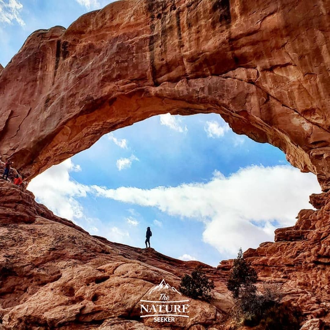
Windows Arch and Turret Arch trail:
- Location: Arches National Park
- 4 wheel drive required to reach? No!
- Hike difficulty: Beginner
- Length: 1 mile loop
This is one of the shortest trails in the entire Arches National Park area and it allows you to see at least 3 different arches as well as go in through all of them. It was one of the first spots I explored when I entered this park and you can get some seriously awesome photographs and videos in this area such as the one you see to the right.
These arches are fully accessible for hiking in, to and through and I highly recommend it as the experience of doing so is something else! The trail is very short but there are parts where you can climb into these arches that makes it a moderate hike.
I’ve taken some awesome photos in these arches more than once and I plan on redoing it every time I revisit Arches National Park! I suggest going early because this part of Arches National Park gets packed often.
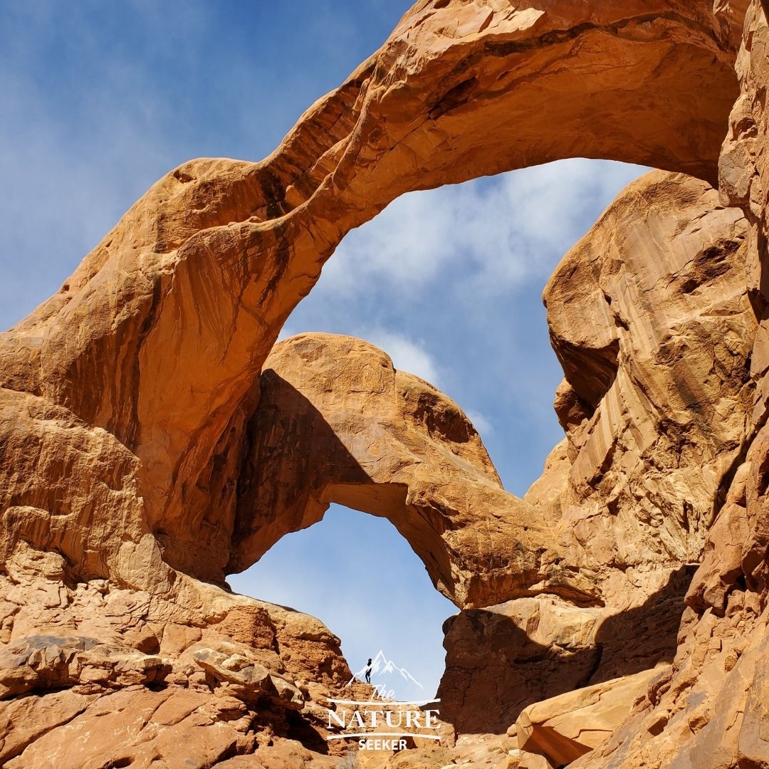
Double Arch trail:
- Location: Arches National Park
- 4 wheel drive required to reach? No!
- Hike difficulty: Moderate
- Length: 1/4 mile
The Double Arch trail is literally right next to the Windows and Turret Arch trails and on the opposite end of the same parking lot. You can’t really miss it as you’ll see the trail leading there, and if not that, then crowds headed in that direction.
The Double Arch is one of my favorite arches in this entire park and it is a delight to explore. The first time I explored it, my friend and I were the only people there and were fortunate enough to get this amazing photo of it at the time. But beware, there are lots of people who visit this arch, so odds are, most of the time you will see it populated with many like minded explorers!
Devils Garden trail:
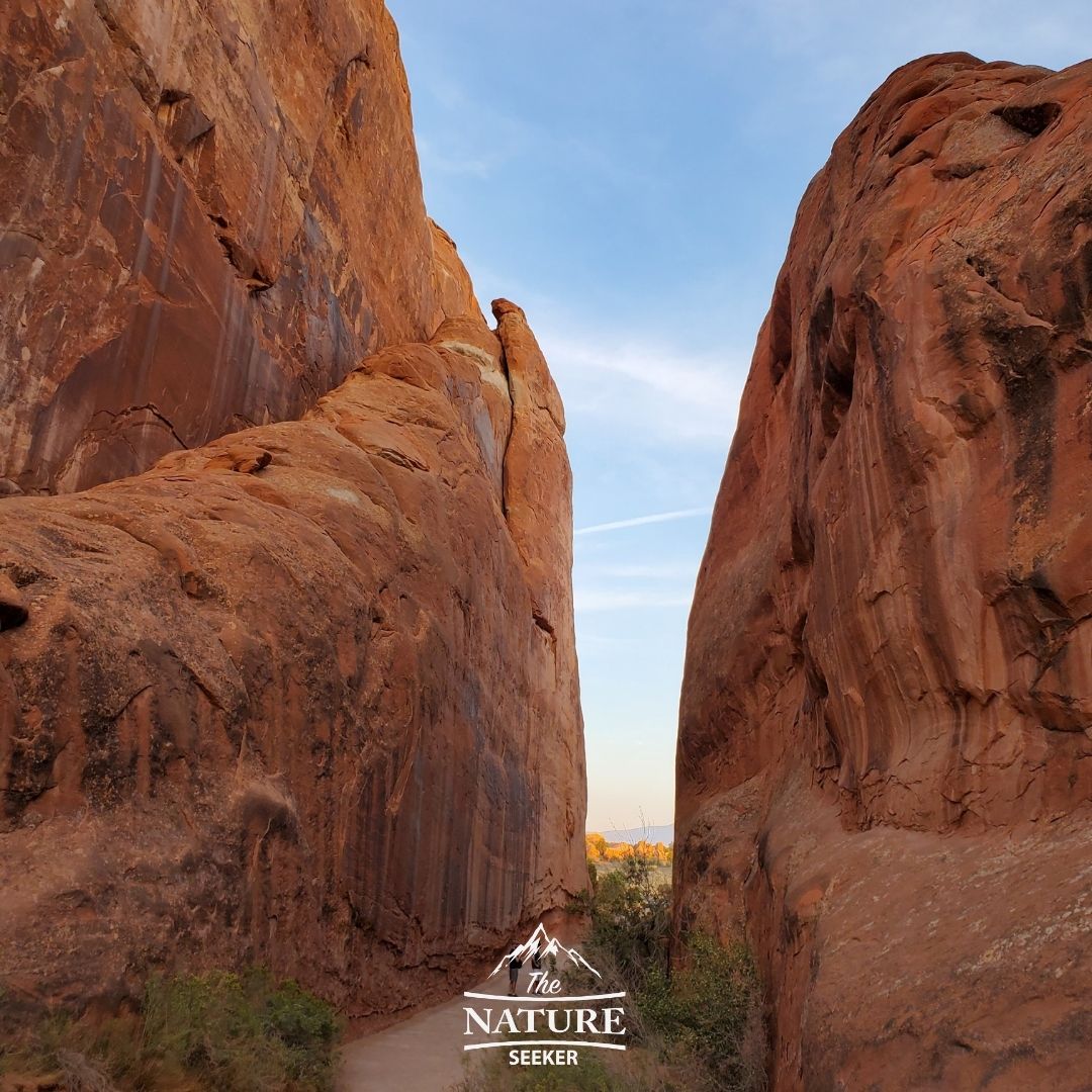
- Location: Arches National Park
- 4 wheel drive required to reach? No!
- Hike difficulty: Beginner
- Length: 1-2 mile
I explored this trail the second time I visited Arches National Park and it’s a really scenic area which has you cross through canyons and see some truly beautiful sights. You can even climb up some of these spots, but the hike itself is really easy, family friendly and it’s located at the northern end of the park.
The picture you see to the right involved my friends and I crossing one of the many canyons there. You can actually climb up some of them, but sticking to the main trail is also an awesome experience as you walk through these beautiful areas. Arches National Park isn’t just an arch heaven, but it’s also a place with many more diverse sights to explore!
Delicate Arch trail:
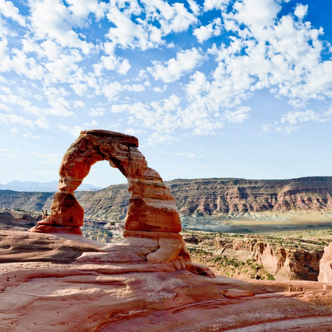
- Location: Arches National Park
- 4 wheel drive required to reach? No!
- Hike difficulty: Moderate
- Length: 2-3 miles
This trail and arch are located a bit south of Devils Garden and it’s one of the only trails in the park I wasn’t able to do. But you can see the arch from the parking lot and it is a very popular arch that requires a pretty long hike up a mountain to reach.
Delicate Arch is one of the most famous arches in Utah so expect to wait in line to get a picture under it, unless you come here during off season periods (winter is best). There are also man pictures you’ll find online of people who visit this Arch at night and if you have a good enough camera, it will be able to capture all of the stars above this area. That is something I personally want to do.
Grand View Overlook trail:
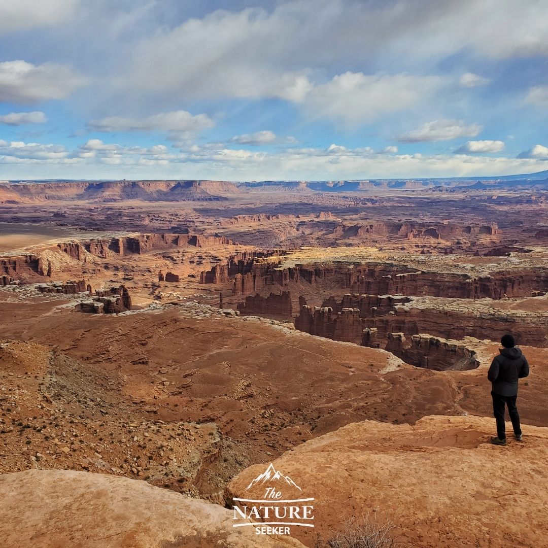
- Location: Canyonlands National Park
- 4 wheel drive required to reach? No!
- Hike difficulty: Beginner
- Length: 2 miles
Canyonlands National Park has a bunch of awesome trails, but I only chose this one because it was my favorite one. It has you basically walk along the edge of one of the most scenic spots in the entire park and cross giant boulders and see amazing sights (see the right image).
For those wondering, you can actually hike or drive by car to the areas below this hike where all the other canyons are. But as for hiking trails, Grand View Overlook is certainly grand in every sense of the word and as I’ve said before: It feels like you’re walking on a balcony overlooking the best parts of Canyonlands National Park!
Hickman Natural Bridge trail:
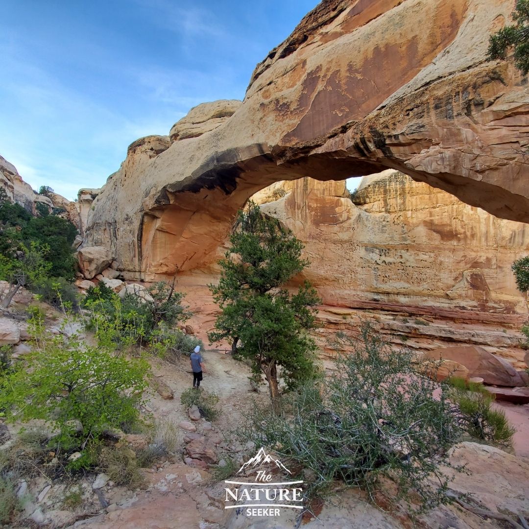
- Location: Capitol Reef National Park
- 4 wheel drive required to reach? No!
- Hike difficulty: Beginner
- Length: 2 miles
This trail is located inside Capitol Reef National Park and it was the only one I had time to explore with the few hours I had in this area until the sun set. It is a VERY beautiful hike to the natural bridge itself and you’re going to cross some amazing places, like little canyons, sandy beach spots, caves, a little river and much more. The trail is just as beautiful as the actual natural bridge you see at the end of it.
And Capital Reef National Park is spectacular to explore and once I do more of that, I’ll write about what else there is to see there, but it considered to be one of the most beautiful parks in the Mighty 5 National Parks of Utah. One thing I can recommend you do is drive across the scenic route there, as it’s quite stunning!
Coyote Gulch (Water tank trail):
- Location: Grand Staircase Escalante
- 4 wheel drive required to reach? Yes!
- Difficulty: Hard
- Length: 3-10 miles loop
This is one of my favorite hikes in Utah but it’s also one of the most difficult to reach. If you’re not an experienced hiker or are OK with driving far into remote areas of Utah, then I would not explore Coyote Gulch especially if you plan to hike it in a day.
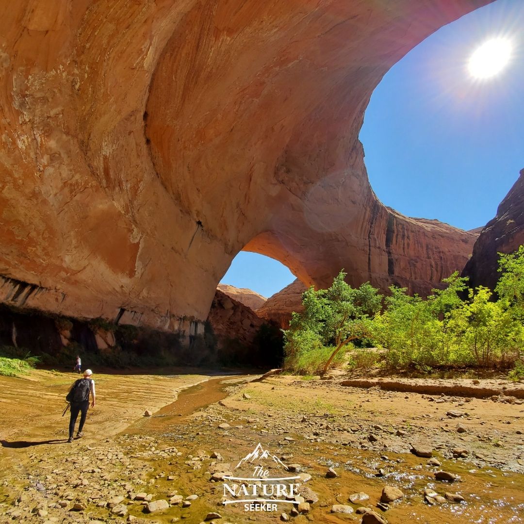
But what you’re going to do here is drive your car far into the Grand Staircase Escalante area and part it in a place called the Water Tank Trail and then hike north to an area where you’ll have to climb down to Coyote Gulch by rope. Once you’re inside the gulch, there are some seriously amazing spots to see, like Jacob Hamlin Arch, Coyote Natural Bridge, Stevens Arch and many more areas like it. It’s tough to reach and the hike to the gulch itself is one you need to be careful with not to get lost on.
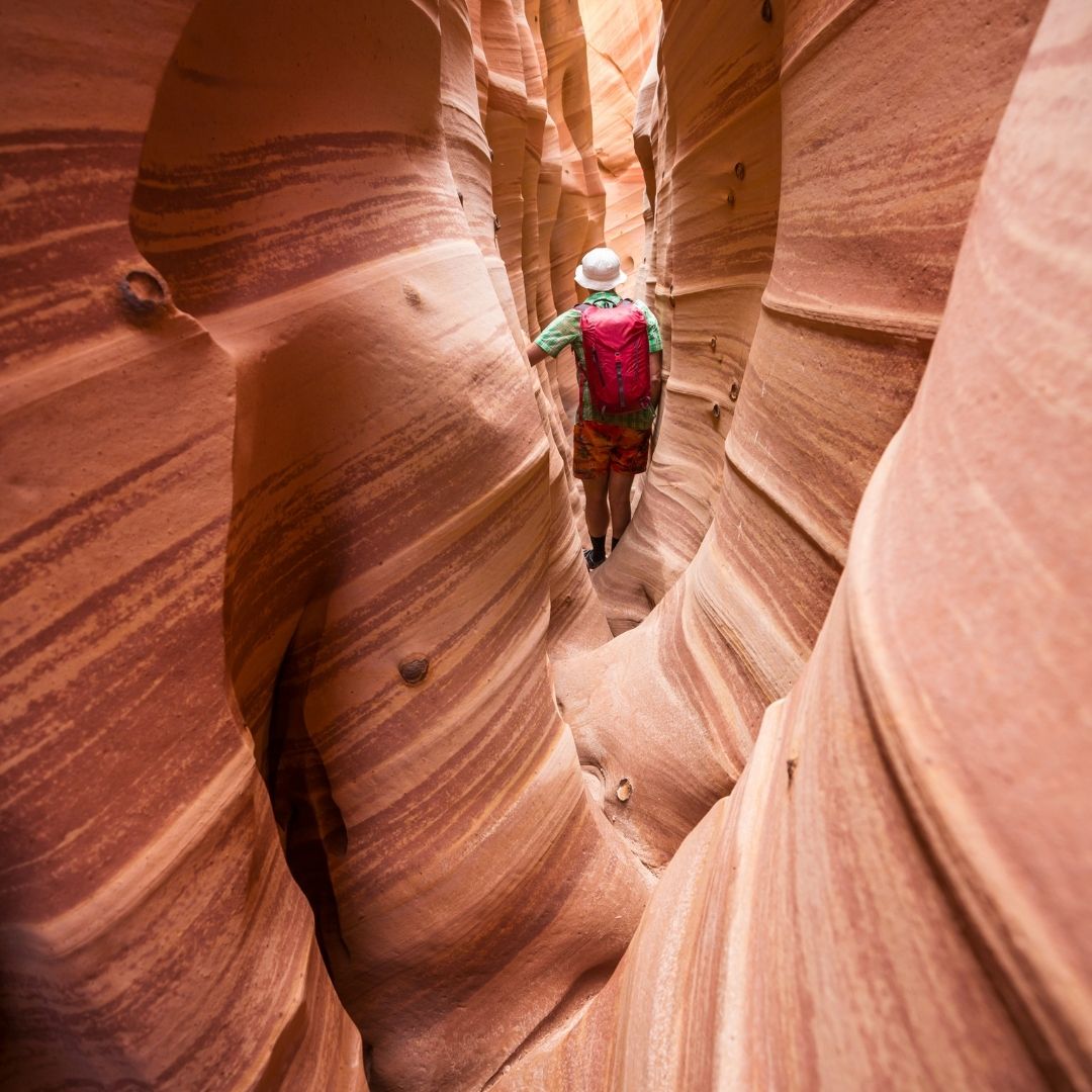
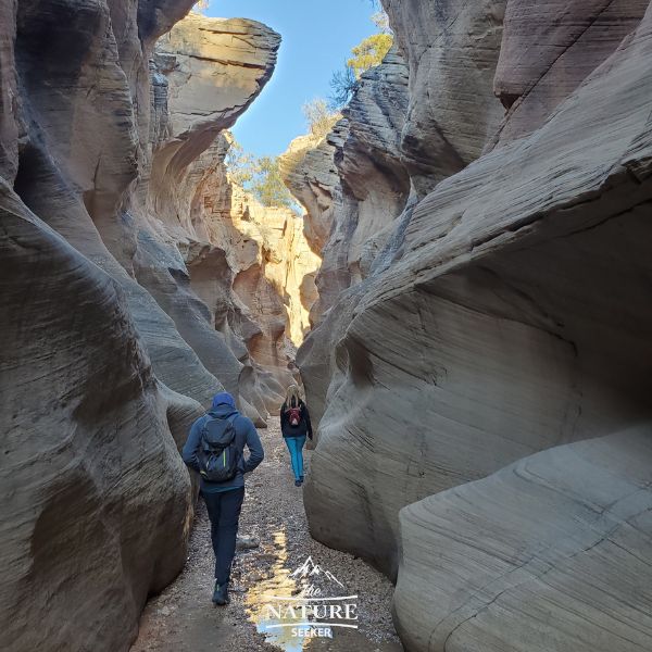
Peekaboo and Spooky Slot Canyon trail:
- Location: Grand Staircase Escalante
- 4 wheel drive required to reach? Recommended!
- Hike difficulty: Moderate
- Length: 3-4 mile loop
This is another spot I tried to explore, but sadly, didn’t have to. It’s 2 slot canyons located next to one another that people typically explore as a single hike. They usually start at Peekaboo slot canyon and then walk out and into Spooky slot canyon, before looping back to the trail head and parking lot.
It gets VERY tight in this region so be aware of this, but it’s located about 20 minutes northwest from Coyote Gulch. So if you can tie in a hike there and here in one day, you’re going to be doing a lot of scenic and challenging hiking!
Note: You can find many awesome hikes in Grand Staircase Escalante (that are not on this specific page but are available in that link I mentioned).
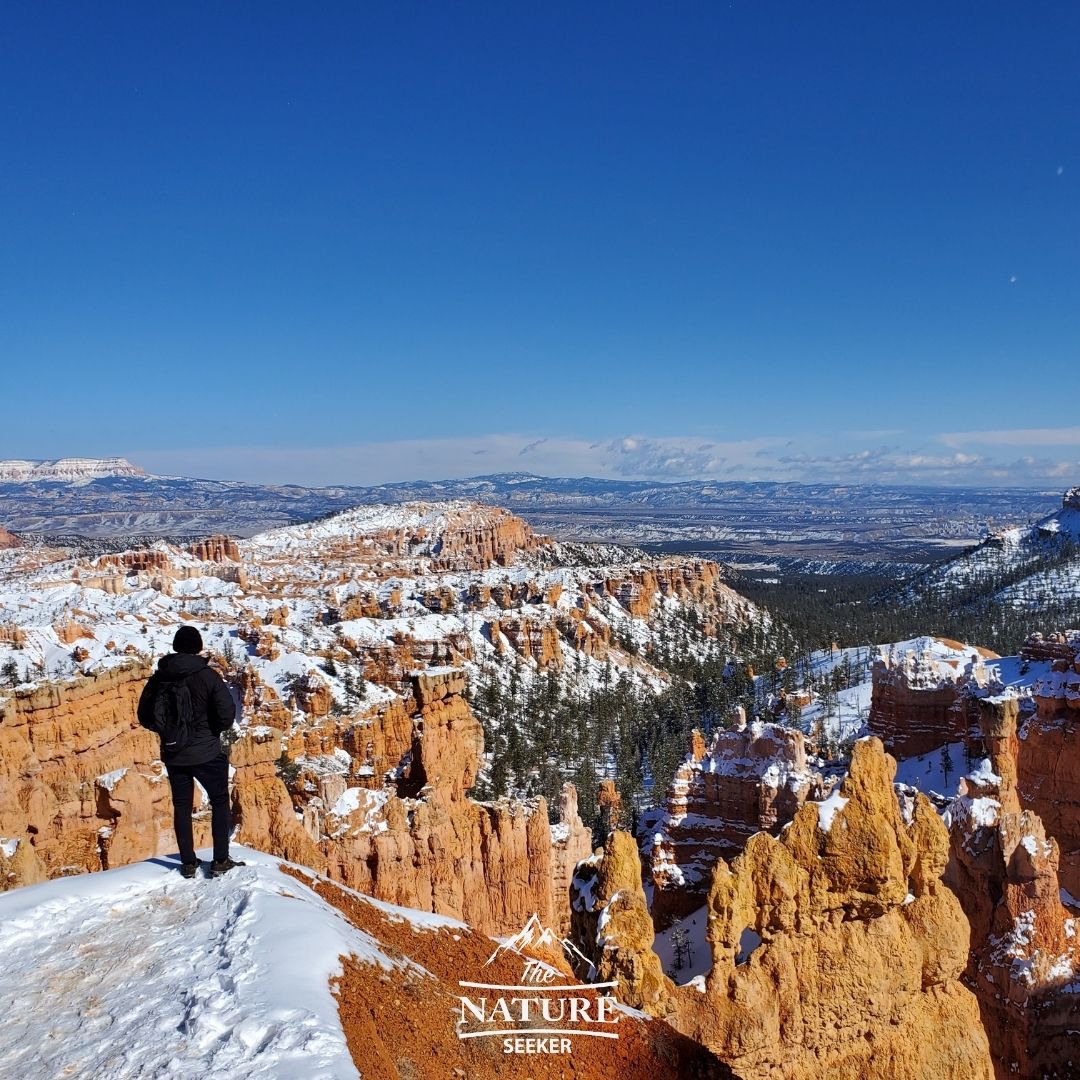
Queens Garden trail:
- Location: Bryce Canyon National Park
- 4 wheel drive required to reach? No!
- Hike difficulty: Moderate
- Length: 3.5 miles
This is one of the most popular hikes I did in Bryce Canyon National Park in the winter. It was one of the only available trails to check out and it was quite a stunning one at that. You walk through beautiful caves, natural bridges and it really takes you deep into the park itself (I also have many beautiful Bryce Canyon National Park photos of all these sights).
I have to admit, visiting this park in the winter was a great move as we didn’t see many people, cars, or other hikers as we walked across this trail and that made it far more enjoyable as it felt like we had the park to ourselves. The snow also added to the beauty!
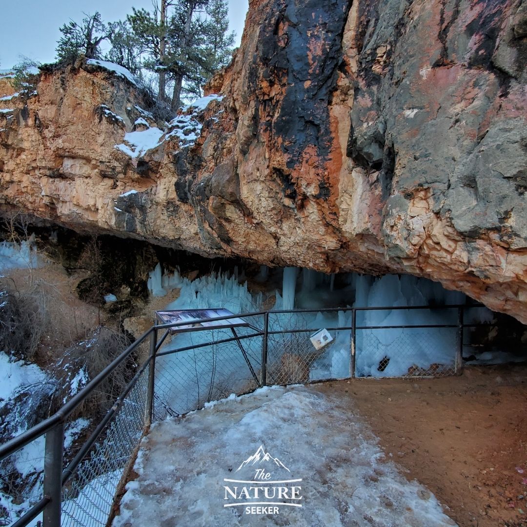
Mossy Cave trail:
- Location: Near Bryce Canyon National Park
- 4 wheel drive required to reach? No!
- Hike difficulty: Beginner
- Length: 1 mile
I accidentally saw this trail when I exited Bryce Canyon and it really is a VERY nice, scenic spot to explore. It takes you through bridges, a waterfall and large cave at the end of the trail. I saw all of this during the winter so the cave had massive icicles there as you can see to the right. This is actually a very mellow, scenic and enjoyable hike that I frankly enjoyed almost as much as hiking through Bryce Canyon. It is something that is family friendly, there is a wide variety of entertainment surrounding it and if you plan to go there with family, I am sure they will all enjoy doing it.
L Cap trail:
- Location: Hildale Utah
- 4 wheel drive required to reach? No!
- Hike difficulty: Hard
- Length: 3 miles
It literally came up on my suggested YouTube videos one day and the person who uploaded it said it’s better than Angel’s Landing, another awesome hike on this list. But this is almost like a “best kept secret hike” because very few people know about it. I included the video I saw that helped me find out about this hike. But it is dangerous and difficult to do, so you’d better be in great shape if you hope to get through it. There will be rope climbing involved.
Observation Point trail:

- Location: Zion National Park
- 4 wheel drive required to reach? Recommended
- Hike difficulty: Moderate
- Length: 6 miles
Observation Point is one of the most beautiful and safest hikes in Zion National Park that’ll allow you to see the very top of the entire park. It used to be that there were 2 ways to hike this trail but due to rock fall, the only way to do this trail is to access it from outside the park.
I have a guide on how to do the Observation Point trail which details how to access the alternative route. There’s a bit of muddy driving required and most of the hike is OK, but when you start to reach the Observation Point lookout is when it gets amazing and it’s totally worth doing in my opinion.
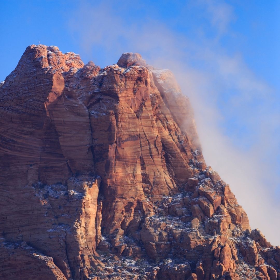
Angels Landing trail:
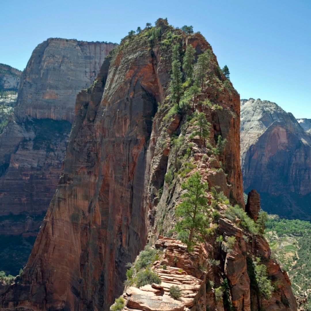
- Location: Zion National Park
- 4 wheel drive required to reach? No!
- Hike difficulty: Hard
- Length: 3-4 miles out and back
Angels Landing is one of the top trafficked trails in all of Zion National Park, and that’s because it’s very scenic, potentially dangerous but also pretty short. It basically gives you the same overview of the park as Observation Point, but from a lower viewpoint. For me, I’ve only tried hiking Angel’s Landing once and I couldn’t make it past the hard part you see above.
This is why presently, I prefer hiking the Observation Point trail as it’s much more friendly for people with a fear of heights, but there’s no doubt that the Angels Landing trail is far more scenic and fun and to do (you can also get a comparison between Angels Landing vs Observation Point for details).
Note: You may need to get a permit to hike Angels Landing during certain months.
The Narrows trail:
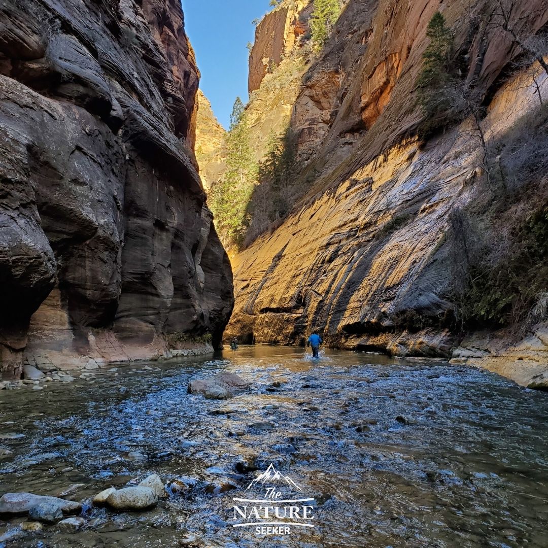
- Location: Zion National Park
- 4 wheel drive required to reach? No!
- Hike difficulty: Moderate
- Length: 14 miles
I’ve done much of the Narrows trail (3 times) and each time I am stunned by it’s beauty. It is an almost fully submersed in water trail that usually requires you wear some sort of safety gear like a dry suite (if you do it in the winter) and at least some sort of decent water shoes in warmer seasons. But you basically cross a long canyon on the northern side of the park and it is often heavily trafficked. There is also a short hike from the parking area to the Narrows trail which is also very beautiful (called Temple of Sinai).
The Subway Trail:

- Location: Zion National Park
- 4 wheel drive required to reach? No!
- Hike difficulty: Hard
- Length: 12 miles
The Subway trail one of the main hiking trails in Zion National Park I have yet to do and this is because of it’s length and permit requirement (due to how popular it is). It is also a very popular trail from which you see many beautiful and iconic photos come out of the park (I think you can see why).
It’s highly recommended, but generally better for people who stay overnight near the park and can get the permit to go there ahead of time. I have yet to do this trail myself because the permit system makes it tough to get (it’s basically a lottery) and because of that you have to get lucky, but I have also found trails outside of Utah that look like the Subway. One in particular is West Fork Trail, but it’s in Arizona.
Chute of the Muddy Creek trail:
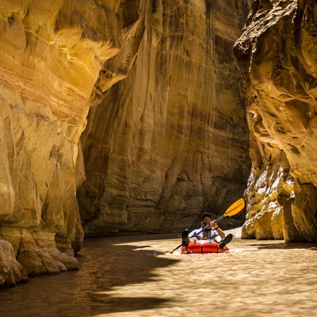
- Location: Near Emery County, Utah
- 4 wheel drive required to reach? Recommended
- Hike difficulty: Moderate
- Length: 15 miles
It is a fairly long and dirty hike that is like the Narrows in some ways, but is basically in mud. You can walk in it for as long as you like (up to 15 miles), and you can even paddle board or kayak in it when the water gets deep enough (as you can see from the picture on the right). The Chute of The Muddy Creek is a famous hike, but also not one that many people who visit Utah know about, so take advantage of that if you want to try this amazing hike.
Jeep Arch trail:
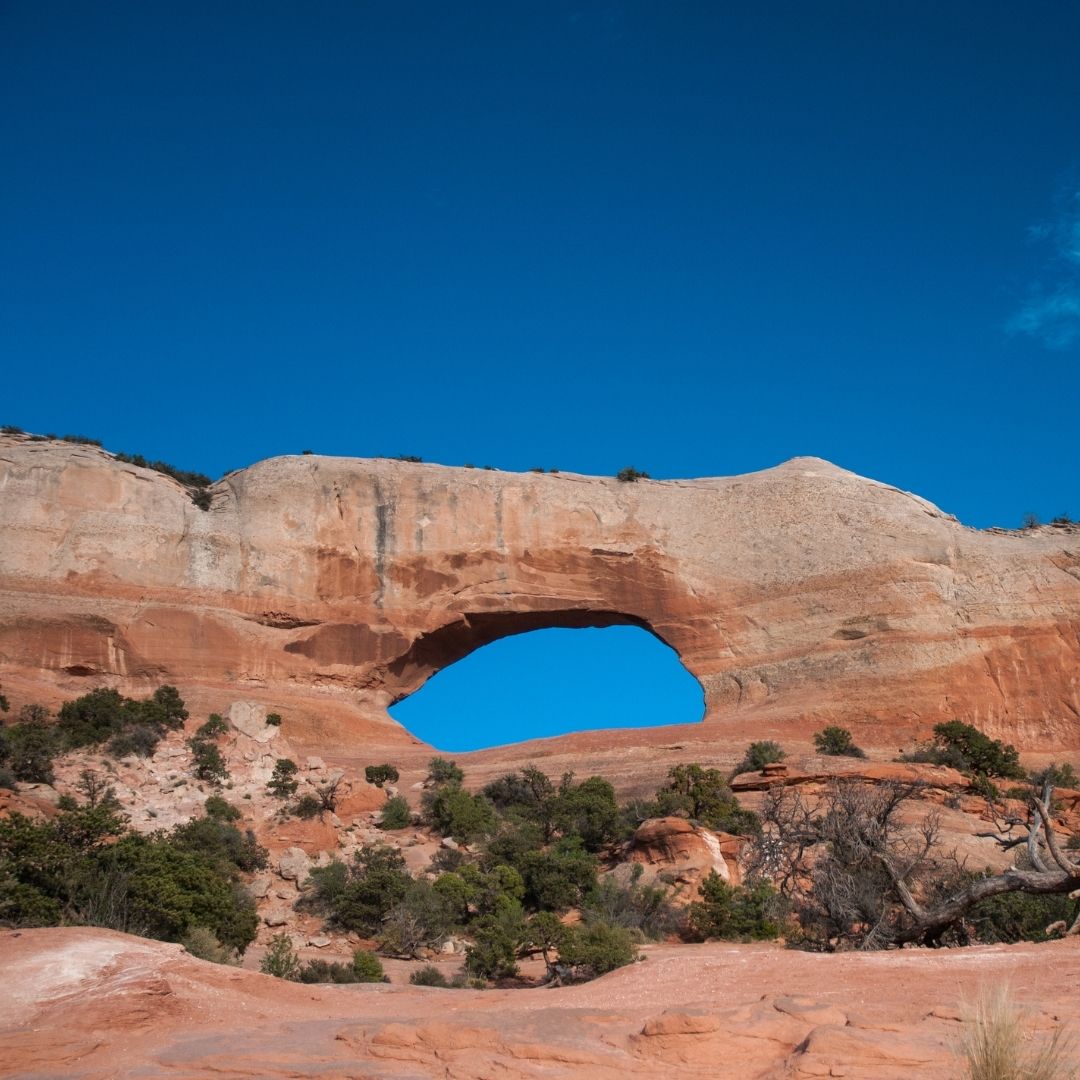
- Location: Moab Utah
- 4 wheel drive required to reach? No!
- Hike difficulty: Easy
- Length: 1 mile
While on my way to see Arches National Park for the second time, I accidentally stumbled upon this giant arch that was literally off the road. The parking lot was full so we didn’t stop, but the arch requires a short hike to it and it happens to be one of the most famous arches in Utah. I believe the reason it’s called the Jeep Arch is because of how close you can park to it. Aside from that, once you get to the top, you can get great views of Arches National Park and other scenic views of the Moab region around it. If you can find the time to make this short stop on your trips in Utah, I’d take the time to do this short hike.
Rainbow Bridge Arch trail:
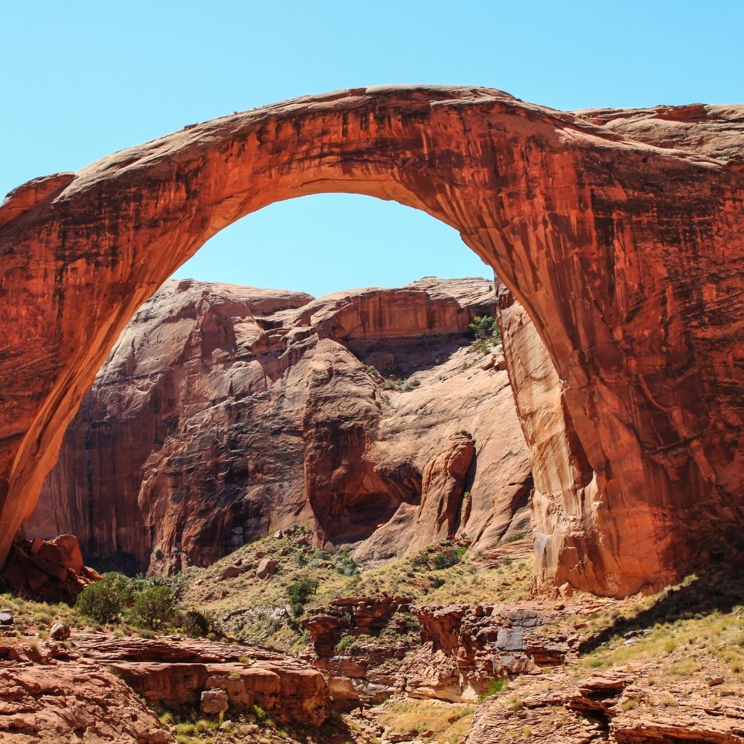
- Location: Glen Canyon Recreational Area
- 4 wheel drive required to reach? No!
- Hike difficulty: Moderate to hard
- Length: 1 to 25+ miles (depending on which option you take
Rainbow Bridge National Monument is a gigantic arch that’s even bigger than the Jacob Hamlin Arch in Coyote Gulch and ironically it’s one of the least famous arches in Utah. In order to reach it, you have to travel by boat through Lake Powell and stop near the trailhead and then hike to this spot (1-2 miles). Another option is hiking a 25+ mile trail from the south to it (but that’s recommended for experienced hikers).
Snow Canyon Trail:
- Location: St. George Utah
- 4 wheel drive required to reach? No!
- Hike difficulty: Moderate
- Length: 4-5 miles
Snow Canyon is one of the most popular hikes in St. George Utah which is a town not far from Zion National Park. I could honestly include a whole list of them here, but if I were to select one for you to try in this area, Snow Canyon would be the top recommendation for the views, the variety of green colors from the forest mixed with the red and white mountain colors and the overall hike experience. This is a great trail for families to try too.
Kanarra Falls trail:
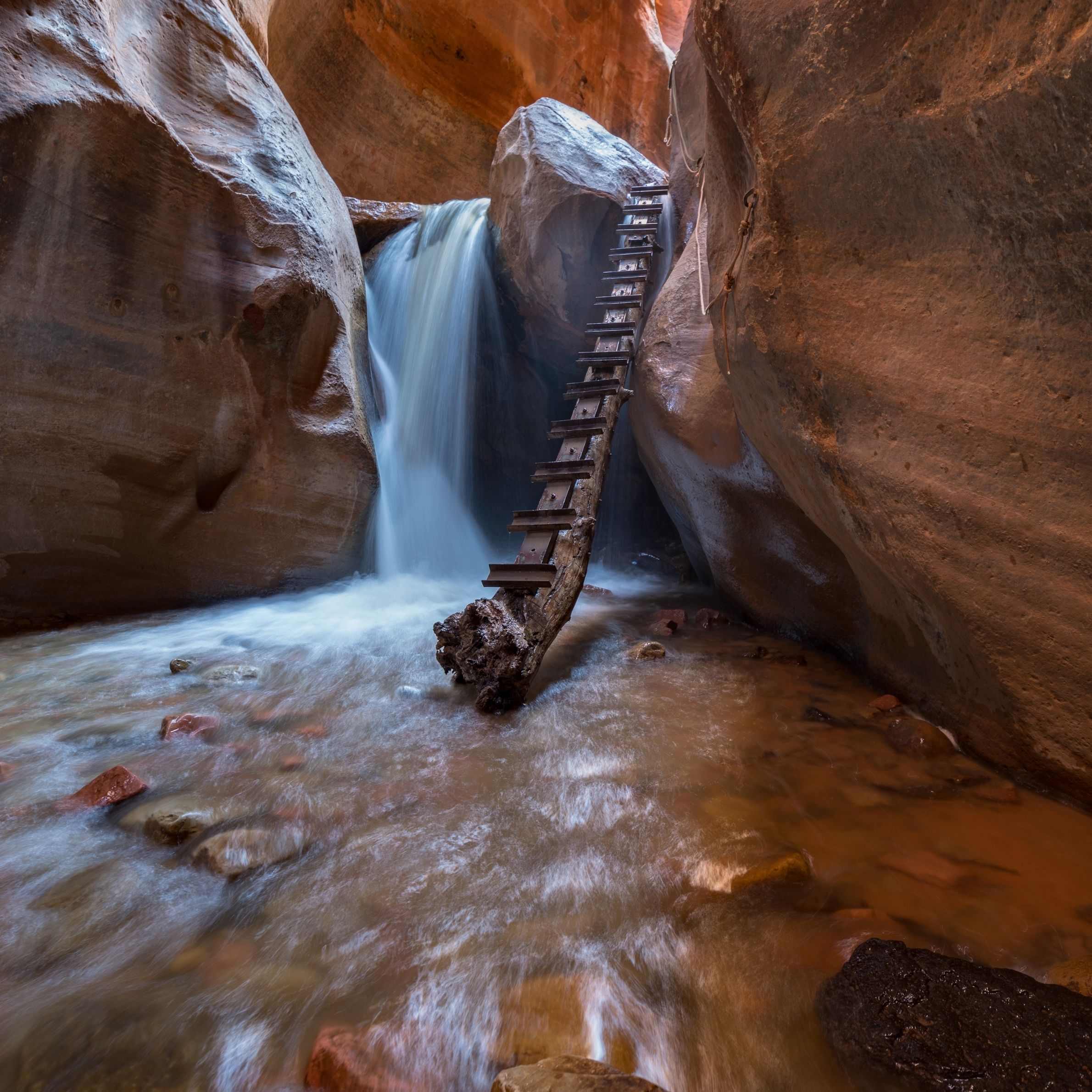
- Location: Kanarraville
- 4 wheel drive required to reach? No!
- Hike difficulty: Moderate
- Length: 4 miles
Kanarra Falls is probably one of the top 10 hikes in all of Utah (and one of the best slot canyons in Utah too) and if you go, there’s a good chance you’ll run into crowds (this is why you also need a permit to get to this hike), but for good reason:
This hike involves you hiking up to a slot canyon, getting into water and following the canyon to a beautiful, but small waterfall with a ladder near it. This hike is stunning in many ways and it’s one I’m proud to see I did (and recommend you do as well).
A few things to know about it:
- A permit is required.
- You will get wet.
- It is usually very crowded.
Fisher Towers trail:
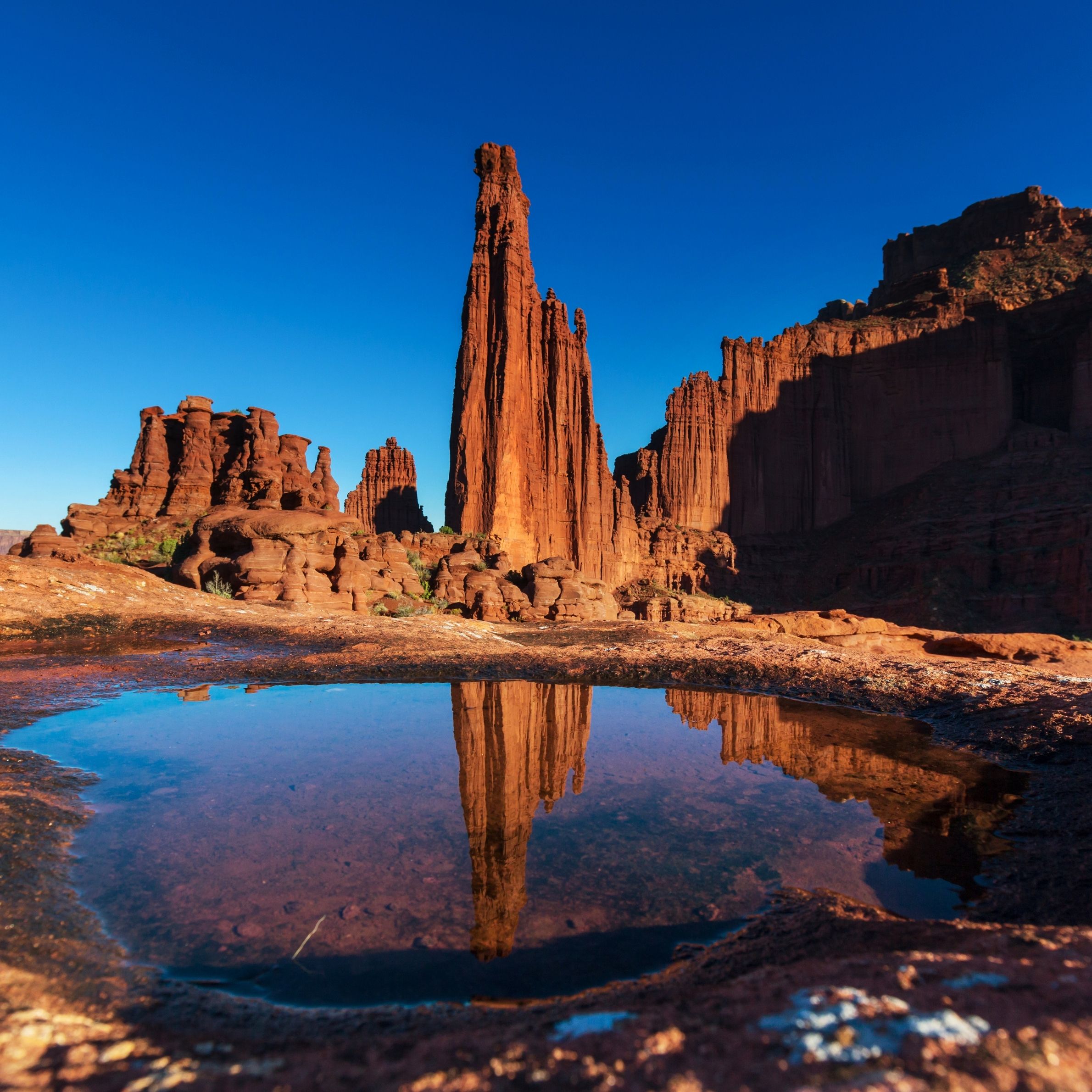
- Location: Moab Utah
- 4 wheel drive required to reach? No!
- Hike difficulty: Moderate
- Length: 3-4 miles
Fisher Towers a very scenic trail that is located not too far from the town of Moab. If you run into large crowds or lines in the main national parks around this region (Arches and Canyonlands), then this is where you’ll want to go. This is a trail that takes you into some beautiful canyons and views that are just beyond stunning. You’ll also get a lot less people on this trail than most of the main ones nearby. This will allow you to enjoy one of the top hikes in Utah State and really enjoy the silence and solitude of it.
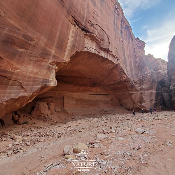
Great Chamber hike (Cutler Point):
- Location: Kanab Utah
- 4 wheel drive required to reach? Yes
- Hike difficulty: Moderate to hard
- Length: 1/4 to 16 miles
This hike is considered tough because reaching it is difficult, as is finding the Great Chamber itself which is the giant arch/natural bridge made out of sandstone that you see in this picture. I do recommend you be advanced before doing this hike because it’s in a very remote part of Utah and you can’t even find an online map for this trail, even in places like Alltrails. I’ve recently done this hike myself and there are 2 ways to explore it:
- The main way is a 16+ mile hike.
- And the other is an 18+ mile drive which takes you close to it, then the hike is 1/4 mile to reach it.
I prefer the second one, but you need an AWD to get there. Alltrails has a map of how to reach Cutler Point by car (and by hiking to it) and I can vouch for this hike being incredible!
Wire Pass Trail:
- Location: Near Page Arizona
- 4 wheel drive required to reach? No!
- Hike difficulty: Easy
- Length: 3 miles
I’m so glad I explored this amazing trail very recently! It’s a short, but very fun walk to a slot canyon that looks a lot like Antelope Canyon. You’ll walk through beautiful river washes, slot canyons and see amazing canyon sights while inside this area.
This trail does require a permit to enter but it’s very cheap ($6+ per person) and the Wire Pass Trail is highly recommended not just for how fun and easy it is but also because of the scenery. On this trail you will be walking through desert washes, tight slot canyons and incredible views all throughout.
Willis Creek Slot Canyon trail:
- Location: Near Bryce Canyon National Park
- 4 wheel drive required to reach? Recommended
- Difficulty: Easy
- Length: 5-6 miles
I accidentally found this very popular hike after showcasing the beautiful Bryce Canyon trail I talked about earlier to a group of people I was with. Being that this trail got such high ratings, I decided to take the group that I was with there and I am glad I did!
Willis Creek Slot Canyon is a very simple mix of a wash and slot canyon walk along a river bed that is very scenic, very easy to hike on and very photogenic! To get there though requires you not only enter Grand Staircase Escalante, but also drive through rough dirt road areas so make sure you go here in an SUV with AWD. No permit is needed to go to this amazing hike and I highly recommend it!
Kanab Sand Caves:
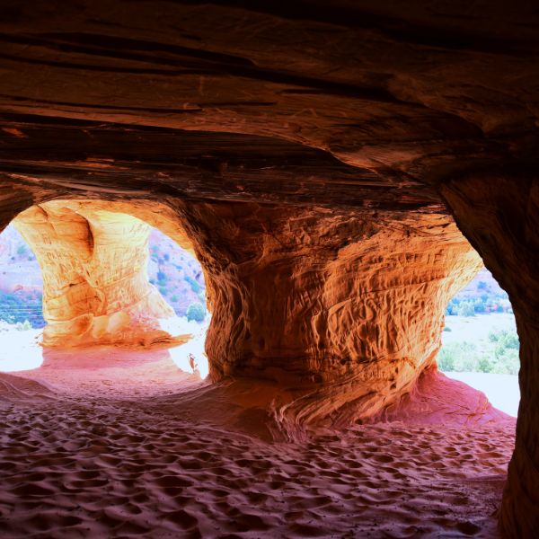
- Location: Kanab Utah
- 4 wheel drive required to reach? No!
- Hike difficulty: Easy
- Length: 1/4 mile
One of the most iconic hikes in all of Utah (specifically Kanab) is the Sand Caves. They are a must do, easy hike if you’re in south Utah (staying or driving through Kanab). The hike here is so simple that just about anyone can do it.
To reach this hike, you’ll first park at a parking lot (Sand Caves Trailhead), then follow the signs to the Sand Caves (it’s a simple 1/4 mile walk), then do a short hike up which will take you up to them. There are about 5 Sand Caves to see here and it’s a very simple, but very scenic spot to explore and you may consider this to be one of your personal best hiking trails in Utah.
Popular questions on hiking in Utah:
What is the best hike in Utah?
There are 100s of hikes across Utah so it’s difficult to rate one as the best hike in the state, but the most popular are the Angels Landing trail, Delicate Arch trail and the Narrows trail.
Is the hiking good in Utah?
The hiking in Utah is absolutely amazing. The most popular hikes are in the national parks of the state while more remote areas like Grand Staircase Escalante have some of the most incredible off road trails available.
What is the most difficult hike in Utah?
The most difficult hike in Utah varies, but most would say it’s either the Subway or Angels Landing trail or El Captain trail all of which are either inside Zion National Park or near it.
Where should we hike in Utah?
Some of the most run hikes in Utah are in Zion National Park. If you are looking for beginner friendly hikes, stick to the ones in the national parks. For more intermediate and advanced trails, go where there are no tourists.
Map details on the above Utah hikes:
- Windows Arch trailhead
- Double Arch trailhead
- Devils Garden trailhead
- Delicate Arch trailhead
- Grand View trail
- Hickman Natural Bridge trailhead
- Coyote Gulch (Water Tank trailhead)
- Peekaboo and Spooky Gulch trailhead
- Queens Garden trailhead
- Mossy Cave
- El Cap trailhead
- Observation Point trailhead
- Angels Landing trailhead
- The Narrows trailhead
- Zion Subway hike trailhead
- Chute of the Muddy Creek hike details
- Jeep Arch trailhead
- Rainbow Bridge National Monument info
- Snow Canyon trailhead
- Kanarra Falls trailhead
- Fisher Towers trailhead
- Great Chamber
- Wire Pass trailhead
- Willis Creek Slot Canyon trailhead
- Kanab Sand Caves