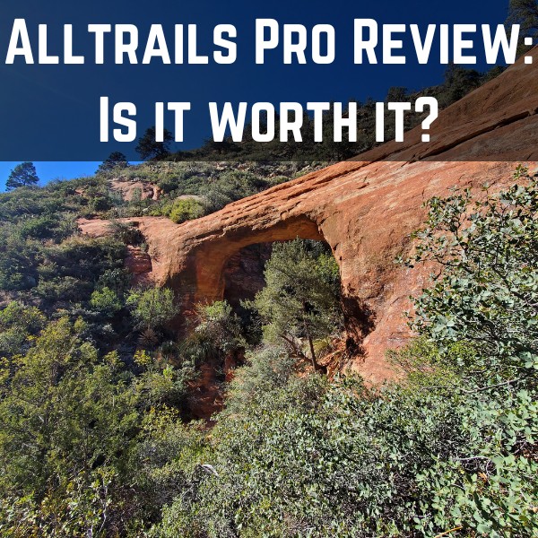
AllTrails Review – I Used to Love it But Then This Happened
I’m going to share some personal stories in this AllTrails review of how this app saved me numerous times which made me love it at first, but then as I became a much more experienced hiker and explorer, how slowly my appreciation for this app eroded and why today I still seldom use it, and what I do to ensure I don’t get lost when I hike.
The main thesis of this AllTrails App review is this:
As a whole, the AllTrails app (specifically the free version) is decent for beginner hikers just looking for popular hiking trails, but if you get more immersed into hiking and exploring new trails, especially in more remote (bad signal) areas, there may come a point (like it did for me) when this app will not only disappoint you, but it may also end up confusing you which is why you need a plan B (I’ll talk about what that is below).
At the same time, the Alltrails Pro app (which is a paid version of it) is a MUCH better option for those other circumstances, and specifically helping prevent you from getting lost and being able to backtrack to safety if necessary. That is what I highly recommend people get.
But overall, regardless of my views on the Alltrails App (free or paid), it doesn’t change the fact that you should absolutely learn to develop your own navigational skills and never solely rely on this or any other trail apps to save you, because it’s never 100% guaranteed. I’ll share the situations I’ve come across where this app has helped me as well as situations where I quickly learned it wasn’t 100% reliable and what I learned to do instead so you don’t run into these situations yourself.
I’ll also be covering the following things in this Alltrails review:
- Details on the free Alltrails app (pros, cons, personal stories which are both good and bad).
- My experiences with Alltrails Pro as well (also pros, cons and personal stories) and if you need the upgrade or not.
What is the All Trails app? How to use it to find hiking trails:
This section of the AllTrails review is for anyone who is a total beginner to the app. I know 99.9% of people know what it is or have heard of it, but just so we’re all on the same page, here’s a quick description: AllTrails is an app designed to help people find hiking trails and outdoor adventures. If you allow it (location permission), Alltrails will show you the nearest trails wherever you are too, thus taking the “guess work” out of the mix.
Here’s some other features (this is by the way for the free version of All Trails):
- Again, it will show you a list of nearby hikes and trails depending on your location.
- You can also manually search for popular hiking trails.
- You can customize your search to seek out trails, waterfalls, hiking distances and more.
- You can use the description, map, photos and reviews of the trail to better prepare yourself and/or see if it’s even worth trying.
- If you are on a trail, you can also open the trail map (and see where you are (if you have a GPS signal available that is).
- For each hiking trail you find, you will also get a map, description of it, details on the length, difficulty of it and reviews from those who have done it.
Then there is an Alltrails pro app version ($29.99 a year):
I’m going to be honest, my knowledge of AllTrails pro is subpar. I did buy it a long time ago but I barely used it. For the most part, AllTrails Pro will help you get better details on your hiking trails as well as download maps in case you lose connection/signal while on a hike so you can monitor where you are.
Update: I’ve been using the Alltrails Pro for a few years and below I will detail my very positive experiences with it.
The pros of using the Alltrails app (free version):
- It’s good to find easy hikes near me (or you in this case).
- It’s also a good app I use for (sometimes) finding waterfalls near me as well.
- Good for beginner hikers.
- Provides decent listings of trail maps.
- Provides listings of tons of hikes.
- Provides good GPS location details to help you identify where you are (if you have signal).
- You can get a good overview of reviews, tips and suggestions from other users on whatever hike or hikes you plan to do.
The cons of using Alltrails app (also free version):
- I would not rely on this app for all your hikes (doesn’t show everything).
- If GPS location is lost, you either need AllTrails Pro or it’s useless in my opinion.
- Searching for hikes near you is often confusing because too many choices pop up and it’s tough to tell them apart based on trail names.
- AllTrails trail markers are marked in 1 color (red) and that can confuse people if the actual live trails are of a different color.
- There are many parks, hikes that do not show up on AllTrails.
- I would absolutely encourage you to develop your own skills for hiking/navigation and not to rely on AllTrails all the time!
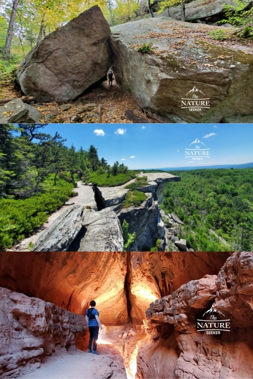
My positive experiences with the free AllTrails app:
I’ve included an image here showcasing some amazing hikes I found thanks to this app:
Story 1:
I was in Harriman State Park hiking a completely customized path that consisted of many different trail colors. While Alltrails didn’t have any specifics to this trail (I was trying to find a place called Lemon Squeezer) because it was not well known about, I had a GPS signal and used it to estimate where I was and which direction to go into.
I did end up finding the right spot, in part thanks to using AllTrails, although the bigger part of my success that day was because I relied more so on the official map of the park instead of the app. And in regards to AllTrails, this was all predicated on the fact that I actually had a signal. Had I not, I’d likely have to backtrack. rely more on the map I had or I’d be screwed.
Story 2:
I was exploring Lake Minnewaska State Park and specifically doing a trail called Gertrude’s Nose. I was doing a specific path of it where the trail would go be tough to navigate at times, but thanks to having a GPS signal and map listings, I was able to determine which was to go to finish the loop I was doing.
Story 3:
AllTrails helped me find a cool hike in Columbia River Gorge by exploring an alternative trail to Oneonta Gorge which I would otherwise not know about.
Story 4:
Generally speaking, AllTrails sometimes helps me find trails when I travel and sometimes I’ll find good tips and reviews as well as preview maps to help me determine if the trail is worth checking out or not.
Story 5:
Alltrails has helped me navigate and find amazing places in Sedona like the Soldiers Pass Caves. There was a part of this trail where I had to steer off it and because it was on the map, I was less worried about being lost.
Story 6:
Most recently I did an amazing hike in New York called Avalanche Pass Adirondacks trail and this was one of those cases where the official map of the area was ridiculously confusing, so much so that I opened up Alltrails, found the same trail and used it on much of the hike to get to the right area, and thanks to Alltrails, I was able to do that.
Story 7:
Recently Alltrails also helped me find an awesome hidden hike in the Red River Gorge area of Kentucky that led me to a beautiful Double Arch. One key for this trail that I learned was that I had to expand the Alltrails map as much as possible to see exactly where I had to go to find this.
My negative experiences with the free version of the All Trails app:
Story 1:
There have been numerous cases, especially in places like Harriman State Park where I could not find any decent maps on AllTrails for the path I wanted to take. I would often get lists of loops and beginner trails which were confusing to figure out and pinpoint. I also had numerous times where I was exploring a trail in this particular park where I just couldn’t find it on AllTrails and had to rely on a physical map instead. I totally understand that Alltrails can’t have every single map there is out there, and Harriman State Park is a bit complicated for hiking, but in hindsight this lack of info helped me become better at navigating on hikes by not relying on it.
Story 2:
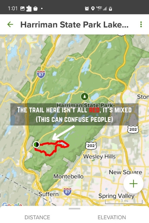
Even when I do follow a hike I find on Alltrails, it may involve doing different colored trails and if I solely rely on the AllTrails map, it appears red for me and that confuses me when in reality I have to pass through trail markers that are of a different color (I mentioned this above).
For example: The picture I included here is of a popular trail in Harriman State Park that combines several small trails to make a 8+ mile loop. It involves going through what is known as the Reeves Brook Loop trail, and if you know anything about it, you’ll know there are actually several colors to this specific trail: Red, blue, white, yellow and possibly more.
I get that when you see specifics on where to go, it’s easier to understand, but when you’re on trails here, sometimes you may miss which colored trail to turn on because you only saw red on the AllTrails map. In that circumstance unless you have AllTrails pro and can download a map to pinpoint where you are, this app can be pretty useless if you are hiking somewhere with no GPS signal.
Update: Alltrails preloaded trails maps now show in light green vs the previous red (you will still see the red though when you use the navigation option).
Story 3:
I think Alltrails can get very annoying to figure out when you go somewhere you have 10 different versions with the named trail. For example, if I type up Coyote Gulch in the search, I’ll get 9 or so different options and I have to manually sort through each one to figure out what to do. Sometimes I’ll find loops and trails that are totally irrelevant to the region I’m seeking to explore. Here’s an example:
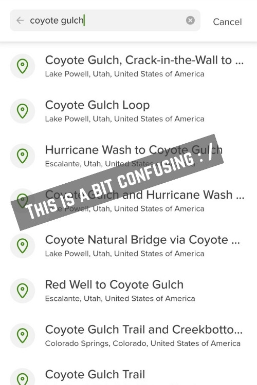
I totally understand there’s variations of hikes you can do in the same areas, but if there were some sort of report on the search bar on the distance and difficulty instead of having to click on each result to find that out. These stories would rack up overtime as I would explore more difficult/complex trails out there and as the disappointments racked up, so did the reality that I could not continue to solely rely on this app.
Note: All of these stories are of me using the free version of Alltrails. In hindsight (which you will read about in a moment), having Alltrails Pro would have positively enhanced all of these stories, especially the negative ones.
Now onto my Alltrails Pro review:
As I said earlier I actually bought Alltrails Pro long ago and it was right before my hike to Coyote Gulch. To be honest, I didn’t use it much (at the time) but very recently, I returned home from a 10 day trip that spanned from California, to Nevada, Utah, and finally ended in Arizona (this happened in November 2022).
In that 10 day period, my appreciation for Alltrails (Pro specifically) skyrocketed because of how useful it ended up being for me, specifically in helping me properly navigate certain trails without getting lost and also if I did wander off the main trail, I could use the offline map and see where I was regardless if I had connection or not to find my way back.
With the Alltrails Pro app, there are 2 specific and major pros worth noting:
1) You can download any trail map that is on the Alltrails index so you have it whether or not you have a signal, meaning if you are somewhere where there’s no cell phone reception, you can still use the offline map and even see where you are on it (this is priceless and potentially a life saving pro). I would highly recommend this as a way to prevent getting lost in the woods (not guaranteed, but your odds of that lessen greatly in my opinion).
2) If there are circumstances in which a specific trail is not listed in Alltrails, there is a “start navigation” option where you basically start hiking and it records (with a red line) which way you are heading on the trail. You can then use that map and trail created to backtrack to where you began. This is exactly what I had to do in Arizona when I was on the Vultee Arch trail and the app greatly helped me here.
Now when it comes to Alltrails Pro cons, there’s 2 things:
1) You won’t have trails for every place you look (it’s just impossible for any trail app to cover all that’s out there). Thankfully there is a navigation tool to start your own trail on the map you can download offline to make sure you can backtrack (this is very useful).
2) I still maintain that you should learn to rely on your own skills to get yourself home safely because no matter how good an app is, if you rely on it too much, you may hinder your own learning/evolution of necessary skills and that may be very dangerous if you ever get lost in the woods and there’s no official Alltrails map of it for you to rely on.
I had one circumstance on that same 10 day hiking trip where I was hiking at Keyhole Cave in Sedona, and Alltrails went crazy when I got into the cave, which would have confused some people, but I just used simple logic to make my way back (this is proof that situations like this can happen).
If you want to know how to cancel Alltrails Pro, here are the steps:
You need to do that through the Google Play store where you look for the app and you can manage your payment for it there (cancel/update it).
Conclusions on the AllTrails app overall:
While I think the free version of AllTrails has a lot of uses and should be installed on your phone, once again I also think it’s a big mistake to only rely on it. Now regarding Alltrails Pro, it is 1,000x better and well worth it for the priceless pros I stated above and it’s only $29.99 a year, a very small investment for a potentially life saving app.
But overall, even if you do get Alltrails Pro, do not ever assume that this or any other similar app is a substitute for learning your own skills to find your way on trails, off trails and where you need to go.mThere are so many easy ways to get lost out there and even miss out on incredible trails that aren’t in the AllTrails index and if you don’t develop your own skills and know which trail you are taking thinking that Alltrails will just guide you through, you’re setting yourself up for disappointment eventually (or maybe something worse).
What about alternatives to AllTrails? Are there better apps?
I’ve seen a few and people have showed me some that they say are better (you can see their recommendations in the comments below). However, the central problem with all of them in my opinion is that you shouldn’t rely solely on them, just like with AllTrails. If you have a personal recommendation for a good alternative app to AllTrails though, I’d be more than happy to hear your thoughts on that below.
Aside from developing your own skills at navigating, here’s a few other things I personally do to avoid relying on AllTrails:
- Research a trail ahead of time and get a screenshot of the map (or a physical one).
- Plot your own directions if it’s a trail that isn’t listed on AllTrails (and even if it is, I’d still do it).
- Find trailheads for hikes if it’s an impromptu hike and take a picture of the map just in case.
Bottom line: Know that AllTrails app doesn’t have everything and don’t solely rely on it and get lazy, otherwise you may eventually get yourself into trouble in doing so. Thanks for reading this AllTrails review! I’d love to hear your thoughts on the app and other alternatives you use as well as stories of when this app helped you or didn’t below!
Fantastic review—thank you! I’ve tried so many hiking apps, and it really takes a few weeks or even months of use to understand their strengths and limitations compared to others. With so many options out there, it’s hard to know which ones truly stand out. I’ve been looking for unbiased insights on AllTrails ever since I started using it a few weeks ago, and I completely disagree with the negative comments about your review. You’ve saved me a lot of time and frustration, and I think I can finally stop searching for the right hiking app—AllTrails seems to be the one for me.
Please clarify.
If I have Alltrails+ and have downloaded a map… what good is it if I’ve lost my GPS signal.
If I’m lost and my phone doesn’t know where I am in relationship to the map, and just shows me a map with random lines on it, how does that help?
Confused.
You will still be able to navigate using an offline map in Alltrails even if you lose a connection.
I enjoyed your article. I was looking for a specific problem new to my All trails and think I will go Pro. My problem, which is new, is that All trails will shut down in the middle of a hike, so random. I have uninstalled and reinstalled with no change. It’s so frustrating. I will switch to Pro and see if that helps. Thanks again for your review.
That’s a very strange bug Sandra and I would recommend you first check out if others are having the same issue. The good news is that Alltrails pro will let you download maps so even if it shuts down, you can still reanable the map offline. I would still recommend using other means to navigate just in case.
You’re right about not relying on it and the need to develop your own navigation skills. The best way AllTrails+ helps you with this in my opinion is with the map printing feature from their website. You can create your own hiking route on the desktop app, save it to your phone, print it out to whatever scale and whatever paper size you’d like and take it with you into the back country with your compass to navigate without the app and as a backup to the app.
Hi Chris, I do like to keep a physical map on me when I hike just in case but I normally rely on a digital version of it. Normally with Alltrails+ I’ll use the navigate option when I do manual hikes that are not listed within the Alltrails library and I’ve found that to be a pretty good way to go for new trails.
I have been using AllTrails for six years. When you plan a hike, you download the hike and follow. I have NEVER lost my hiking signal and position on the downloaded map. This includes all over California, Utah, Colorado, Idaho, Montana, Oregon, Washington and Alaska.
I have also successfully used the “Navigation” function in most of these areas also. The only thing that bugs me is when AllTrails makes small changes to the operating system and I have to get used to a new set up or a new look. Anyway, AllTrails is pretty darn good and really hasn’t let me down in over 500 hikes and more than 3000 miles.
I agree with most of your points Mike which is why I still use this app today.
My daughter Laura turned me on to the Alltrails app. It had been 33 years since I last backpacked in the mountains. Of course, back then, it was Geo Survey map and a compass. I was amazed at what Alltrails could do. Quite remarkable. Well worth getting the free version and trying it. I liked it. Laura and I went on a 4 mile hike where I used Alltrails. It was straightforward so I didn’t need the app to find my way. But I liked that it marked our progress on the trail, what elevations to expect, time elapsed, and other info. I let the 7 days expire and bought the Pro version for a 1 yr subscription. $24.99. All those Geo Survey maps weren’t free, either, you know. As you said, being able to download a trail with waypoints, trail junctions and the Geodesic info is very valuable to a hiker, as long as you keep your phone charged. In my life, I have hiked different parts of the country. I look forward to downloading the trails i have been on with a new perspective. For any serious trip, I would also bring the paper maps and compass. As many have noted, stuff can happen where the phone is compromised, like running out of juice. What do you use for navigation then, especially in wilderness areas, where trails may not be well-marked or confusing? However, for a 1 or 2 day hike, I would rely on the phone only. I also have a Topographical Map app on the phone that can expand the map beyond what Alltrails gives you. It’s interesting to see what is around you. Alltrails gives you a limited map area centered near the trail. But that can be moved around also. As noted, Alltrails can’t give you every possible hike that exists. But it can suggest a lot of hikes that I don’t know exist. Also the trail reviews have a lot of valuable and interesting info about the trail contributed by hikers. I find that info helpful also. All in all, I think it is a really good app for a hiker to have, especially the Pro version where you can download your trail. Well worth the $$ for a serious hiker/backpacker IMHO.
Yeah all these points you make I agree with Fred and I’m glad that Alltrails has helped you find a lot of other new hikes to explore safely.
The only feature AllTrails is good at is buzzing you if you divert from the selected trail. This has kept me from unintentionally bushwhacking more than a few times. But almost everything else about this product is a fail.
1. Search results clear if you want to back out of a trail selection. Redoing the search pushes you to the first selected trail and forces you to select from a sidebar of “Nearby Trails”.
2. There are so many spam reviews as to make the review section trash. I respect and appreciate all real reviews — helpful ones! — from fellow hikers and wish AllTrails made it easy for us to point out the spam reviews to clean up that section of each trail profile.
3. The profile section is all about points and followers. They refuse to allow me to set up the Suitability parameters in my profile, and thus require me to reset those parameters with every search. As #1 shows, this means I am constantly having to go into the Filters to make those selections. Such an easy fix for them and such a waste of my time otherwise.
4. Directions are rarely correct. I am often told that I’ve arrived when the trail head marker and safe parking area aren’t even in sight.
I’ve made numerous request submissions to fix the above. They go ignored. I’m convinced AllTrails is falling apart. Their developer team is either unskilled or seething with contempt toward users. I tried to pull up AllTrails in the AppStore today and it’s nowhere to be found. This must mean something.
Hi Alison I like the specifics of all your arguments and it adds more objective ways to look at Alltrails. I am wondering if most of these issues you mentioned were experienced on the free version vs the pro version though? I ask because as soon as I upgraded, the main things I used and continue to use this app for (with great results) are:
1) The navigation via maps I download in bad reception areas.
2) The buzzing you mentioned helps a lot when I’m off trail so I don’t get lost in the woods.
3) Being able to navigate offline in general.
Ok, that title is a click bait title. And then ‘this’ happened as if some major screw up happened with Alltrails, but nothing of that sort in the article. It’s a general review of Alltrails.
The criticism of Alltrails getting ‘confused’ in a cave is not fair. It’s not really Alltrails app specific problem. You do know what happens to gps in a cave right?
Hi PK, so here’s a few things to mention that’ll give you more context on my position with Alltrails:
1) Regarding Alltrails disappointing me, this was with the free version where I couldn’t get an accurate use out of the navigation option on a trail that wasn’t in the index of the app and the area where I was hiking had no connection.
2) There was also a confusing and frustrating period in the same park (Harriman State Park) where certain trails that WERE listed in the Alltrails index were tough to navigate because the trail loop I was on involved changing to different colored markers. Now this is in part due to Harriman Park being tough to navigate and my skills (at the time) with navigating being poor, but the point is when I was at that level and needed Alltrails, I wasn’t able to use the way I had hoped and it made for having to figure out on my own how to finish the trail, which in hindsight made me a better navigator.
3) This review of the app went through several updates, the first one was made around the same time as the 1st and 2nd situation I mentioned above occurred and I have updated the post accordingly since then to show how much my opinion of Alltrails has improved.
4) I’ve become a pretty big fan of the pro version of Alltrails and absolutely recommend that.
5) Regarding the cave, we’re talking about Keyhole Cave in Sedona. Well that wasn’t the classic type of cave you may think, it’s really a giant opening in a mountain with a small cave inside. I’ve been in deep caves before like the Chasm of Doom in Joshua tree, and it’s obvious why GPS or any connection would be bad there, but in the case of the Keyhole Cave, it’s believed that there is a vortex there so that might impact things.
Now that last situation wasn’t mentioned to criticize Alltrails. It was to point out that strange anomalies can happen so you need to be able to have secondary ways to navigate if the app doesn’t come through which is really the thesis of this review.
I hate to sound mean and I really respond to articles but this one was so ridiculous I just couldn’t help myself. As many others point out, the idea that the color of the trail on Alltrails should match some randomly chosen color code for the trails at the location is so laughable I almost thought the author was joking at first. I find it hard to believe any, other than the author apparently, was actually confused by this. Secondly the author claims he is going to offer alternatives and then offers none. I have used Alltrails Pro for years and there is simply no other app that works as well for such a relatively low price. It has saved me from getting lost many times. And it only seems to be getting better. The trail preview feature the have added is fantastic. The Hiking Project, Gaia GPS and the National Parks app are also excellent backup apps. And Avenza is create for downloaded maps, but nothing quite matches Alltrails. There, in a paragraph I have offered more useful info than the article author.
Well I’m glad you didn’t get lost at least 🙂
Color-coded trails he probably meant, something similar to how it is done in Hiking Project App.
Yes that is sort of what I’m talking about, but here’s an example:
1) Let’s say I’m hiking in a park where there’s many different colored trails.
2) I choose to do a loop trail that is featured on the map, but it involves passing through different colored trails.
3) The app I’m using shows me the colors of those trails, but has a red line (or something indicating where to go) that is next to that so I can tell which color trail I need to turn to.
With the current set up of the Alltrails app, if I use the free version, I’d have to monitor the turns closely as I’m walking to make sure I don’t miss it and in parks like Harriman State Park, they are SUPER easy to miss. With Alltrails pro, I won’t be able to see the colors either, but I’d be able to more closely monitor my progress and know where to turn in a much more specific measure so I don’t miss the necessary turns at the different colored trail markers.
I’ll look into that Hiking Project app you mentioned, thanks!
The complaint about being confused because the red trail on All Trails maps doesn’t match actual colored trail markers is just, I have to say, silly. They have to use some color to mark out a trail route on AT and they chose red. Nothing says that the AT trail color is supposed to match the color marker of individual trails. I don’t know of anyone else who has ever been confused by this. It seems to be a very odd complaint.
I think I need to adjust this article to say that it’s a potential hole in the app, not so much a complaint but for more context let me explain what I meant Steve:
1) I was a beginner hiker at the time I noticed this “issue” and most people who hike in my areas are total beginners. Of course following the red line is easy when the trail itself is simple to follow, but there’s a second part to this.
2) The park I was hiking in was Harriman State Park and that is an example of a place where there’s so many mixed hiking trails with different colors, rare trail markers and very few listings on Alltrails for it. A popular loop there there (like Reeves Brook) involves following 4 different trail colors and while Alltrails shows you the red line version of that loop on a map, it’s also easy to miss those markers and turning onto a new color on that loop because of how rare the trail markers appear in that park.
Reliance on the app in this case could lead to issues if you’re not aware of this. Having Alltrails pro in that regard would be the solution for it, but in my case I had to learn to pick up on these tips impromptu when I was hiking and in hindsight, it made me better at navigating without relying on the app.
This was a good review but the complaint about All Trails using red for their route and it not matching up with trail marker colors doesn’t make much sense.
All Trails HAS to use some color for their route, so of course whatever color they use is not going to necessarily match the individual trail color. Surely you didn’t expect the All Trails route to use individual trail colors?
I think it is beyond their capability to match their route color with a trail color, and I certainly didn’t expect that from the app. And it certainly didn’t confuse me when it didn’t match. And some trails don’t even have colors. What then?
This seems to be placing too high an expectation on the app. Is there even another trail app that does this?
Oh, I and agree, you should never place blind faith in a mapping app, whether it be All Trails or Google Maps.
Hi Steve, thanks for your comment but let me elaborate on the part about this app not showing the proper trail colors. I totally understand that it’s not perfect and can’t exactly reflect the proper colors on it’s online map vs what the trail marker colors are in real life, but at the same time, people’s reliance on the free app vs pro version vs their own skills makes a complete difference contextually speaking, and let me explain what I mean:
I made this argument about the trail colors for a place called Harriman State Park and specifically a trail called Reeves Brook Loop trail, where the loop is actually you following 4 different trail colors, but on Alltrails it shows as all red because that’s just the default color there. And I know more than a few people (myself included when I first started hiking and not knowing what I was doing) who would mistake the map they saw on Alltrails and literally think it’s a red trail when in fact it’s not.
This place (Harriman State Park) has many official and unofficial trails (mix trails together to make your own loops or in and out trails) and at least half (if not more) are not listed in Alltrails which is totally understandable, but here’s where context matters:
If people are clueless on navigating and do a trail like this (and there are tons of places like this all around the US), it’s easy to miss the right turn on the Reeves Brook loop trail (it’s happened to me and even when I thought I had this trail navigation down). Furthermore, if they rely on the free app and lose signal, they won’t be able to see the map and navigate properly.
If they had the Alltrails pro version, downloaded the Reeves Brook loop trail, then it would be fairly simple to stay on the right course, follow the red line and make the right turns at the different trail colors.
But that too has limits since full reliance on the Alltrails Pro has it’s cons in that you may get lazy and not really develop your own skills. So what happens if a trail you’re on requires a turn or you need to adjust where you’re going? Then you need your own skills and that’s where if you know how to navigate, don’t fully rely on Alltrails, do a little bit of research ahead of time from the official map and download it on your phone and follow that as a plan A or B and use Alltrails in combination, that would be best and in fact, that’s how I’ve mostly navigated around Harriman State Park and any place where the trails were complicated to figure out. In fact, with this park, I’ve hardly ever used Alltrails because I’ve wandered into trails that aren’t in the Alltrails index. I used the official map of that park and logically figured out where I was, which in hindsight are priceless skills to use here.
Alltrails is not perfect and of course, having it reflect the right trail colors is also foolish considering trails change and colors for them change too (I’ve seen this in Sterling Forest State Park where a trail that was white on my map ended up being red). In any case, you HAVE to be ready for unexpected turns and situations and never fully rely on Alltrails or any other app to get you out of a bad spot.
In that situation or when I have to adjust my trail runs and hikes to see something else or get out of the woods before it gets dark requires me to know what I’m doing and not rely on an app to tell me where to go. Too much reliance on an app to “do that for you” is a major risk I would never recommend anyone take.
I do highly recommend Alltrails Pro, but the free version can have massive limitations in places like this park and other spots, something to seriously keep in mind and avoid if you’re not experienced in navigating in the woods.
Thank you for the article. For my longer hikes I download the Alltrails map to my Garmin. This way I have a backup and it is on my watch.
It is a great backup.
I find Alltrails to be a great resource and well worth the pro costs.
I have to agree with you there too Geoff. I actually have Alltrails pro on my other phone (haven’t reinstalled it on my new one yet), but it’s not a fix all solution and people need to be careful to know when to use it and when not to.
I’m a horseback rider. I use All Trails Pro and GAIA GPS together. They each have pros and cons. I also rely on my own ability and my horses. He’s very good at finding his way back to the trailer and his food! Lol
I wish I had a horse GPS to guide me back to my site haha!
For me, the most compelling reason for going pro was ability to download maps before I get to the trail because many of the trails don’t have good cellular signal.
I completely agree with you Jatin. In rare cases, depending on the trail and lack of connection reliability, getting the Pro All trails version may be necessary for a lot of people. I’ll likely be using that on my future hike in a pretty remote hike called Devils Path or whenever I am in the deep canyons of Utah.
Thanks Vitaly, After reading your review I am quite interested in downloading it to try the Free version first.
Hiking seems easy at first glance but there are many precautions to take as you have dug deep into many other blogs also. I want to ask you is this app available worldwide or not.
Alltrails is on the Google Playstore and probably the Apple store too so I’m guessing if you have an android of iPhone, you can download it anywhere. Whether or not it has maps worldwide is a different story and I’m certain that there’s plenty of trails and options that aren’t included in the index of this app.
Hello Vitaliy,
As an experienced hiker, I would like to add a few words here. I totally agree with you that you can never rely solely on an application – that’s what I am constantly speaking to young people who think that they have got everything in their hands (phones). The technical stuff can fail you for whatever reason, and the most common is the loss of signal.
What I would like to emphasise is that beginners should definitely go for a Pro version and the others can make use of the free version. Hence, they will be safer in case of getting lost, no internet connection or loss of GPS signal.
Of course, artificial intelligence is sometimes very confusing, so before you start, you should better check all offered routes and find the best or easiest one.
However, people who know they are not so good at orientation should definitely have someone experienced with them, or report their intended hiking route to someone who would know where to look for them (just in case).
It’s really helpful for the beginners to visit your site and get ingormed before starting the hiking adventure.
Thank you very much for adding to this topic and I agree a lot with your other points and safety tips!
Good stuff!
I do feel like you’re reaching with a lot of the cons:
1. It doesn’t show everything. I feel like this should not only be expected but also appreciated. The day *everything* is mapped will be a sad one, exploration and adventure will lose a lot of their meaning if/when that happens. Plus, imagine the amount of resources needed to map EVERY trail.
2. Surely we can’t expect a product/service with these many features to be entirely free… Especially when you *should* (obviously not always but on more complex hikes at least) not depend on anything digital when doing an activity like hiking.
3. This is an integral part of software design, reaching for simplicity and standards. There isn’t a standard for color markings in trails, how could a service like All trails ever get that 100% accurate? Much better to lead the way and try to standardize it yourself to reduce complexity. I think this is more of a pro, pretty straight forward for a regular user to understand what red = trail path.
4. Same as 1…
5 and 6 – absolutely yes! Especially #6, relying on your own skills, which makes the cons from above even more of a reach imo.
Hi Marco, I agree with some counter points but just to clarify:
1) When I say it doesn’t show you everything (Alltrails), the context of that isn’t that it should show everything, it’s that people reliance on Alltrails thinking it shows them everything they need makes them lazy from learning necessary skills.
2) I’m not saying Alltrails need to give it’s best features for free. I’m a businessman and totally understand that value often needs to cost something and Alltrails pro has good value and is decent to get for many situations.
3) The part about the color markings in the app, I’m just pointing out the flaws from my own experiences. Sometimes this simplicity has helped me and other times it’s confused me a lot.
Vitaly, thanks for this great AllTrails Review. As a beginner at this sort of thing, I think it would be really worthwhile for me to download this app onto my phone. I take your point, though, that if I find myself somewhere without GPS, I maybe quite lost and not know how to find my way back. I guess, then you would recommend a course in map reading for someone new, so that would be a good Plan B?
In that case I would recommend reading my post on not getting lost in the woods Jenni. The best advice for beginner hiker I offer is to do very simple loop trails where getting lost is tough and to get comfortable with that before trying harder trails.