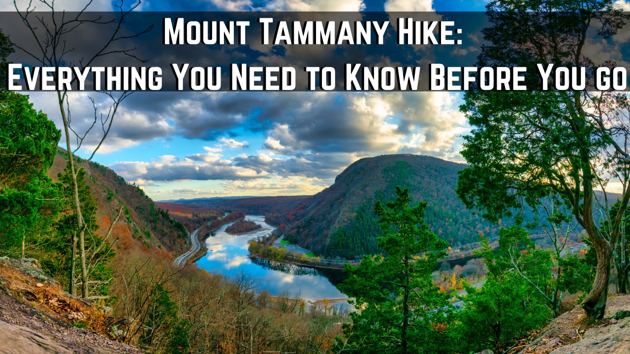
Mount Tammany Hike – 5 Things to Know Before You go
I’ve done the full Mount Tammany hike 4 times so far and in this article want to share things you need to know before you try this trail as well as what to expect from the moment you start it to the different ways of doing it depending on your skill.
Most people who try the Mount Tammany hike do it because it’s popular, and most of those people (at least from my run ins on the trail with them) don’t really do much research ahead of time (They just do it on a whim).
The problem with this is that the hike is difficult for most people and without knowing what’s expected of you physically, what to bring and so forth, you are going to make this experience much more difficult than it has to be and I’ve seen enough people suffer on this trail who didn’t need to, so just take the time to read this first, make the proper adjustments before going and you’ll enjoy this hike much more!
Quick info on the Mount Tammany hike:
- Name: Mount Tammany
- Location: Delaware Water Gap
- Hiking distance: 3-4 miles (loop and other options available)
- Difficulty: Moderate–hard
- Hike rating: 3 out of 5 stars
- Recommended hike? It’s worth doing once for the views but the hike itself isn’t all that fun and there are better alternatives around the Delaware Water Gap area in my opinion. Although I’ve done this hike a number of times, I personally don’t go out of my way to come here unless it’s with new company that’s never been here. It’s a fun one time hike in my opinion.
Here are the 5 main things to know about the Mount Tammany hike:
- It’s the most popular hike in all of Delaware Water Gap (one of the most popular in NJ too).
- There are 3 ways to hike this trail (details below).
- The red dot trail is the most popular and hardest way to hike it.
- There is an easier blue blaze trail you can take to the top of Mount Tammany.
- There is a beautiful swimming hole near the Blue Blaze trail called Dunnfield Creek.
These are very basic things to know about the Mount Tammany hike but in a moment I’ll be explaining the details of the ways to do it, the swimming hole area and how to explore this trail to actually get it done and get the most out of it too.
3 different ways to do the Mount Tammany hike (map included):
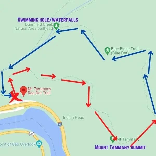
There are 3 ways to do this short (but tough) hike. Here they are:
1) Most popular method: Mount Tammany loop (3-4 miles). It’s moderate.
- Start at the Mount Tammany red dot trail, take it the top.
- Then take the blue blaze trail (blue dot) back down.
- Overall, this is about a 3-4 mile loop.
This is the trail I’ll be showcasing how to do shortly.
2) Mount Tammany backwards loop (moderate):
- Start at blue blaze trail, go up to Mount Tammany.
- When you reach the top, take the Red Dot trail down.
- Same 3-4 mile loop.
3) Hardest trail option (strenuous):
- Hike up the Red Dot Trail.
- Hike back down the Red Dot Trail.
- Overall, this is about 3 miles but it’s the highest elevation gain/loss.
1) Getting there:
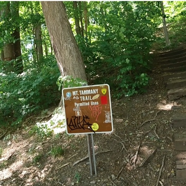
The trailhead is located off the road (I-80). Here’s the Google listing for Mount Tammany red dot trail.There is a parking lot with picnic tables and a sign to indicate you’re there (red dot trail, and it says Mount Tammany). The parking lot to my estimate fits about 30 cars and does fill up quickly depending on when you go. My suggestion is to arrive on a weekday as you will most likely find a lot of open spots and/or if you go on a week, do it super early before the parking lot fills up (it’s usually packed before 12).
Now if you do arrive and it’s filled up, the good news is that there will be another parking lot available only 30 seconds away. It’s a plan B but ideally park on the first parking lot. Once you do, the Mount Tammany sign is hard to miss.
Starting the Mount Tammany red dot trail:
The moment you begin the this hike, there is no “warm up” or anything. You start on steps and work your way up. In fact, I would say for the first 1/2 a mile, the incline is steep most of the time and you had better be prepared (see my post on why hiking is such a complete body workout for tips on this). Is it something that’s impossible? Of course not and most people do fine on this, but it isn’t easy for the majority of people who do it.
Tips:
- I don’t suggest this trail for those who have joint issues.
- If you’re really set on going, I would suggest bringing trekking poles (my preferred choice is the Trailbuddy Trekking Poles).
Making your way up the Mount Tammany hike (first 1/2 mile):
It won’t be long after you start the hike before you hit the first overlook and it is very beautiful, but the trail will mostly zigzag for 1/2 a mile before you begin the even harder scramble further up. While you are on this scramble, do not that the trail markers may be more difficult to spot but you should be OK if you go when there’s a lot of other people. Sometimes they’ll be on rocks and other times they’ll be on trees.
Getting lost on this trail is not something that happens often and if you are worried about this, check out my getting lost in the woods article for basic trail reading concepts to keep in mind to avoid it. Now again, I have to point out that the first 1/2 mile is usually the most difficult for people as there’s a lot of incline mixed with scrambling to do. But at the very least it isn’t long before you start before you reach this beautiful overlook and for what it’s worth, the main summit overlook that comes after is also as beautiful if not more so.
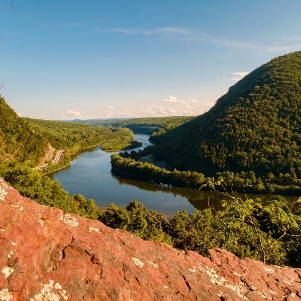
Reaching the Mount Tammany overlook:
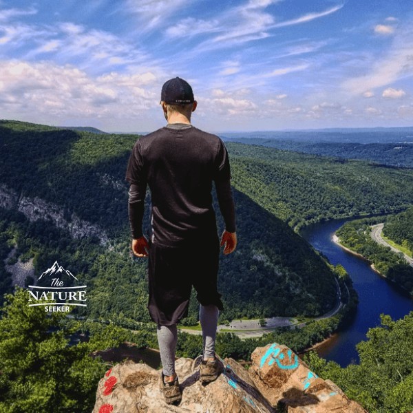
Once you finish the incline and the hike flattens out, you’ll get a nice break for awhile until you reach the official summit and overlook of Mount Tammany. Once you do, it’ll be a pile of giant white boulders and you can usually tell you’re in the right place because there’s always a lot of people there. You can elect to remain at the top or take the boulders a little bit further down (scrambling required) to reach an even nicer overlook and view of the interstate and Delaware River. That’s actually where this particular photo was taken. From here, it’s impossible to go further.
Keep in mind if you go down there, you will have to scramble back up and that can be tiring, especially considering you just finished hiking up the red trail (your choice). On the good side though, if you do go down here, there won’t be as many people so you may find more opportunity to take nice photos without anyone interrupting you.
Completing the Mount Tammany hiking loop:
After you reach the summit, you can either:
- Turn back around and head back down the same red trail.
- Or you can do what most people do which is turn left at the summit. This will take you through a 1/4 mile trail which honestly doesn’t even look like a trail, but it will meet up with the blue blaze trail.
Since we’re doing the option 1 loop from above when you reach the trail marker for the blue trail, you’ll continue to follow the path from the overlook (not the red trail down) until you reach a fork which shows the blue blaze trail. On it, you’ll turn left and take the blue trail down. This will go on for about 2 miles.
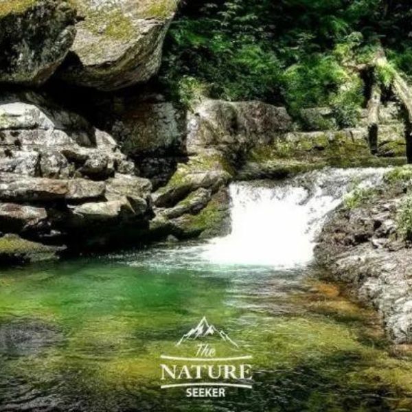
The path is a steady decline which for people like me is very welcome after the annoying incline of the red trail. I personally ran down this trail but that might be a bit much for some so you can just take your time here. You’ll reach the 2 mile mark around the time you hit the swimming hole and waterfalls next to it. That’s a personal favorite of mine on the whole hike to stop at, take a dip and freshen up. Once you pass the swimming hole, you’ll cross a bridge and continue on the blue trail.
You’ll even cross another fork which turns to a green trail, but you’ll ignore it and keep taking the blue trail down. You’ll pass by some nice gorges and another bridge about 1/2 a mile after the waterfall/swimming hole. This will take you a large parking lot that is actually that plan B parking lot I talked about in the beginning of this post.
You’re going to want to stay to the left of that parking lot and what you’ll look for is a sign for the same red trail to Mount Tammany. When you do spot it, it’ll take you up a short flight of stairs, then down and on the other end is where you’ll come to the same parking lot you started at. This will complete the Mount Tammany hike.
More questions about Mount Tammany trail answered:
How long does the Mt Tammany hike take?
It takes most people about 3 hours to hike Mt Tammany.
Is it hard to hike Mt Tammany?
There are 2 trails that go up to Mt Tammany, red and blue. The red trail is hard to hike up while blue is more moderate.
Where do you park for Mount Tammany Red Dot Trail?
There is an official parking lot called Mount Tammany Red Dot Trail on Google maps which will take you straight to the official trailhead.
Is Mt Tammany trail open?
Yes the Mt Tammany hiking trail is open.
Are dogs allowed on Mt Tammany trail?
Yes you can bring dogs to your hike on Mt Tammany.