How to Hike The Kakiat Trail Without Getting Lost

If you’ve heard of or are serious about hiking the Kakiat trail (at Harriman State Park), make sure to read this article about it first so you know exactly what to expect. Despite this hike being very popular, there are a lot of confusing elements to it and mixed information out there about it that can get you into trouble (such as getting lost). This post will clarify everything you need to know before you hike here.
Quick info on the Kakiat trail hike:
- Name: Kakiat trail.
- Location: Harriman State Park (NY).
- Hiking distance: 6-7 miles (NOT a loop trail, but there loop shortcuts).
- Difficulty: Moderate to hard.
- Hike rating: 3.3 out of 5 stars.
- Easy to get lost? Somewhat, trails markers are scarcer the deeper you go into the woods.
- Main pros: Good variety hike with nice views, boulder hopping and more.
- Main cons: Simple to get lost, pretty difficult in spots, not a loop trail.
- Recommended hike? I honestly think there isn’t anything special about it, so do a shorter version of the Kakiat trail or mix it in with other trails in the park for better experiences (more on this later).
What is the Kakiat trail?
It’s a hiking trail that is on the southern region of Harriman State Park. It spans from west to east.
- If you start on the west side of this trail, you will begin at Ramapo Dunderberg Trailhead.
- If you start on the east side of this trail, you will begin at Kakiat Park (this park is right outside Harriman State Park).
The trail is an A to B point, meaning that if you start on the western end, you will finish on the eastern one (or vice versa). There are also a few other options available in which you can do a loop trail, but that will start on the Kakiat trail and take you off it, into another colored trail, and back to the same end point. I will be showing you a few options that are available below.
The trail marker for the Kakiat trail is white, but do note that there are multiple white trails within Harriman State Park, including the Appalachian Trail, so if you choose to hike the Kakiat trail, make sure you start on the correct point and follow the proper white trail.
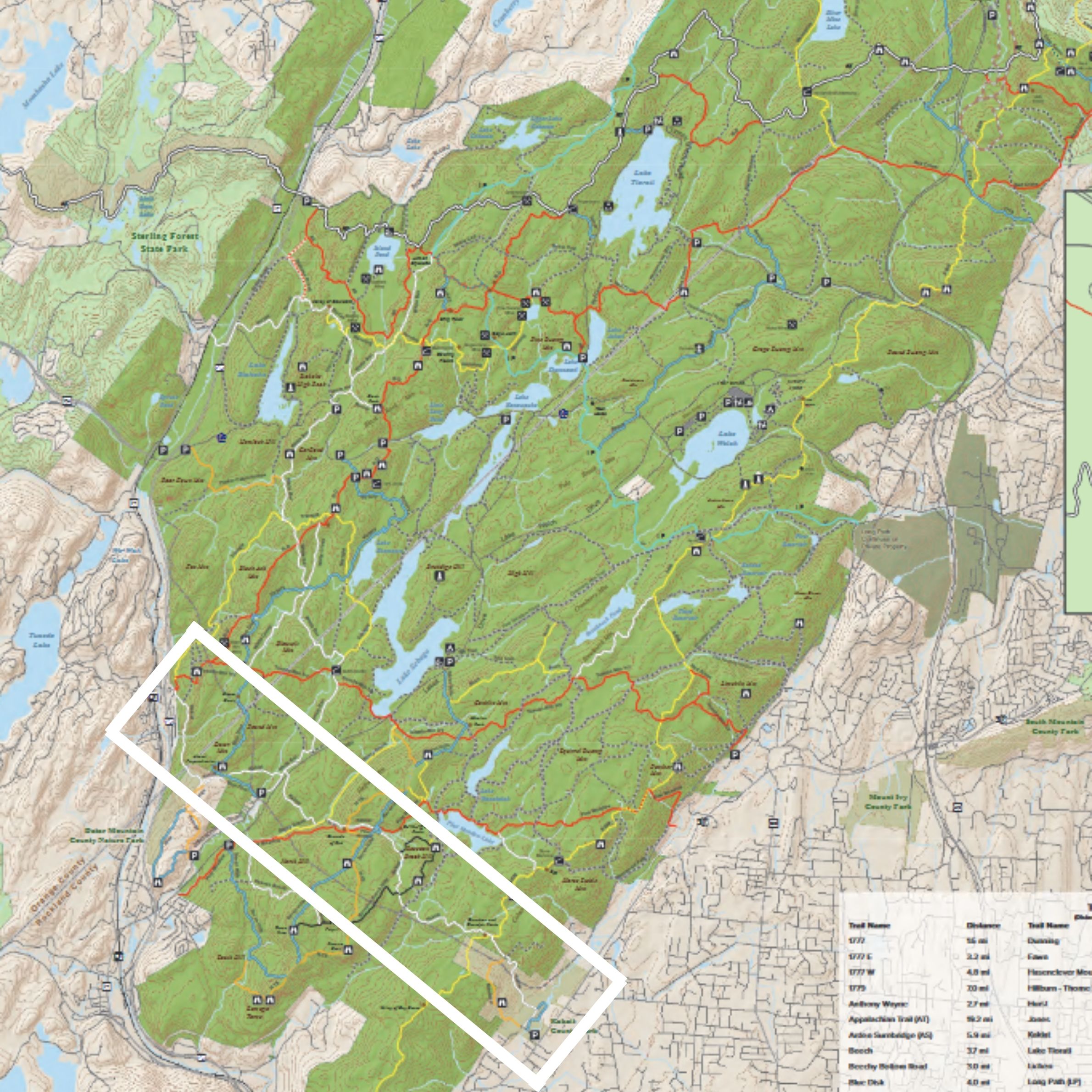
I included a small map on this page to indicate what the trail looks like, but for a further detailed map of the park (and trail), check out the official Harriman State Park map here. Thus far, I’ve done about 90% of this trail from both points and so I’ve seen what it has to offer. There are some pretty nice spots to check out, but for the most part, there isn’t anything overly special about this hike that you can’t find on other trails in Harriman State Park.
I know I said it before above, but the trail is not simple. It is very up and down, very rocky in most parts and the deeper you go into this trail, the harder and more scarce the trail markers are, making it more likely to get lost if you’re not careful.
The 3 main ways to do the Kakiat trail:
These options all have either a different starting point and even a loop option.
1) Full 6-7 mile Kakiat trail:
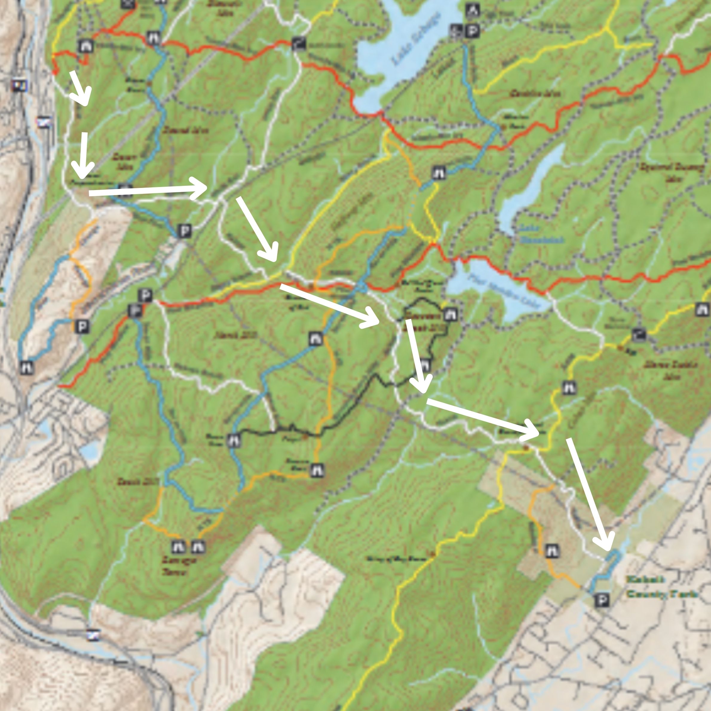
Again, you’ll begin at either the western end, and work your way to the eastern end, or vice versa. Since I’ve seen it looks like on both end points of this trail, I’ll tell you right now that the eastern end is the better one to start at (at Kakiat Park basically).
The Kakiat park itself is really nice, and officially it’s outside Harriman State Park. As you get deeper into the trail, you will begin seeing signs like what I posted here warning you that you are entering Harriman State Park and to be careful (in other words, they’re telling you that this is NOT a loop trail).
If you’re going to do the full Kakiat trail, you may want to have someone drop you off one of the end points, and meet you at the other end. Otherwise, don’t bother doing this trail fully. As you make your way on this trail, you will go up several hills, tight wooded areas, a few creek/gorge areas and cross several other colored trails. Make sure to know how to follow the trail markers to avoid getting lost in the woods or potentially straying into a different trail.
2) Kakiat short loop option 1 (about 3 miles):
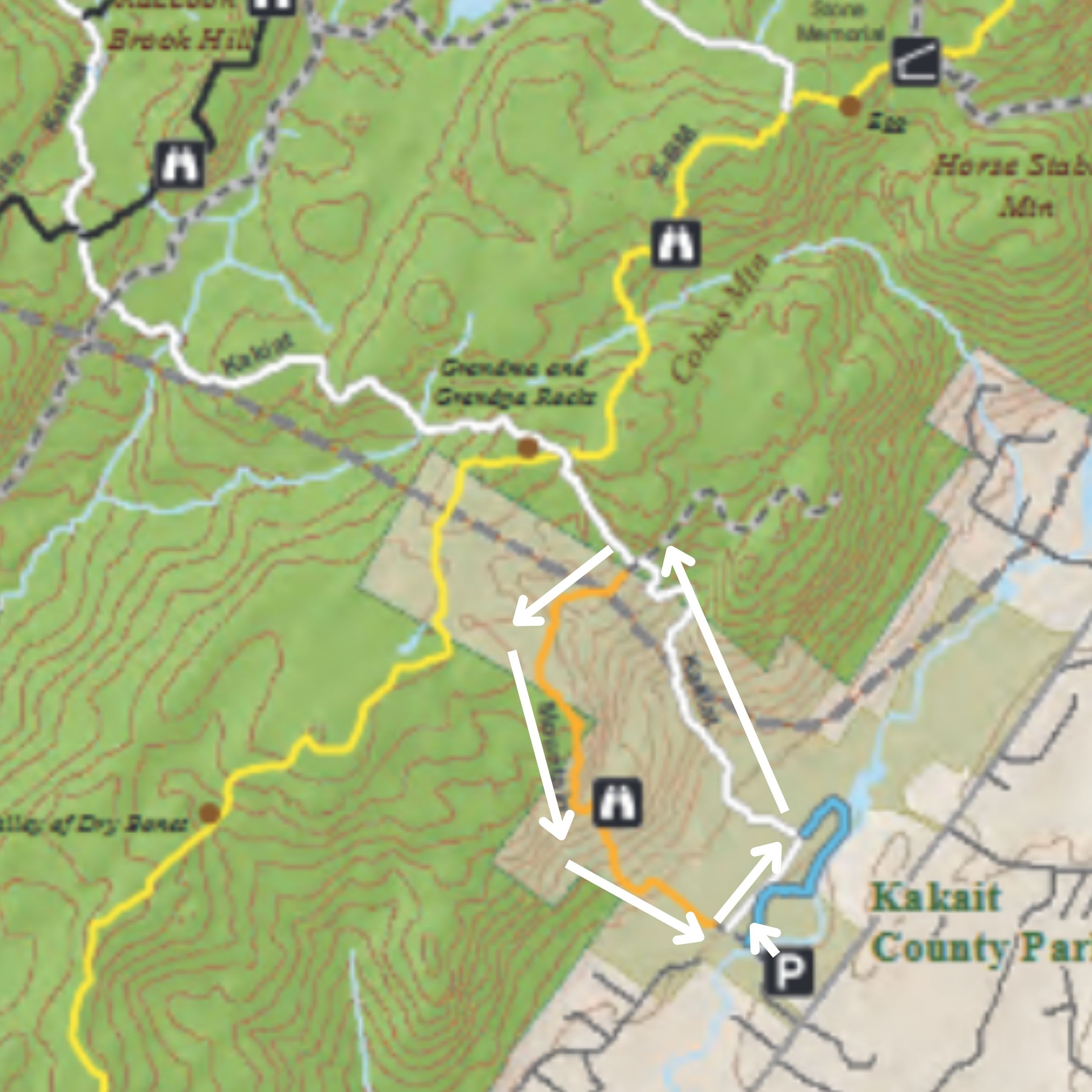
There are ways to do parts of the Kakiat trail, and then return to the same starting point (loop), but you will need to cross over into one or more colored trails to do it. Here’s the most popular one:
It starts in Kakiat Park (eastern end). You will enter the park, cross the bridge, then a blue trail (keep moving further). Then you will come across a split on the trail. The right will take you on the Kakiat trail, and the left will take you on the orange trail which is known as the mountain loop. If you take the white trail (right), you will follow it for 1/4 of a mile before it turns left and takes you uphill.
You will then walk uphill for about 1.5 miles before coming to an intersection where the orange trail marker appears. Follow the orange trail marker and it will take you around, up to a nice scenic overlook, and then back down to the same starting point (Kakiat Park). I’ve done this trail and I enjoyed it. Personally, I thought the orange trail was much more scenic and more difficult to walk on, but if you want to do the loop there, this is how it’s done.
3) Kakiat short loop option 2 (about 4 miles):
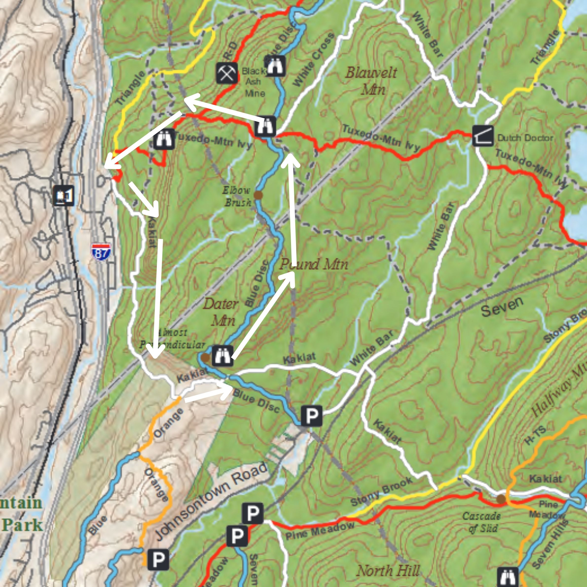
This one is on the western end of the park. You’ll start on the Ramapo Dunderberg Trailhead (there is no public parking here so you will need someone to drop you off). You will take the Kakiat trail eastward. It is VERY uphill and rocky from the start. You will follow it for about 1.5 miles.
You will cross an orange trail marker (ignore it and keep going on the white trail). You will shortly after come across the blue trail intersection. Make a left and follow the blue trail (north bound) for about another 1.5 miles. After 1.5 miles, you will come across a three way intersection for 3 trails: Blue (which you’re on), red and a white trail (not the Kakiat trail).
Turn left (you will be on the red trail). Stay to your left on this red trail (there will one intersection with another red trail that goes right, ignore it). Follow the red trail back to the Ramapo Dunderberg Trailhead to complete the loop. This one is more complicated so I recommend doing the first option, especially if you’re not an intermediate hiker.
4) Other options to do the Kakiat trail:
If you’re an experienced hiker who knows how to navigate, you can start at one end point of the Kakiat trail, and then follow it to other trails, then work your way back around to the same start. That’s how I have been doing it the several times I’ve done this trail, each time covering more and more of the Kakiat trail. You can look at the official Harriman State Park map to come up with a custom loop trail for this (again, be advanced if you decide to do this).
Conclusions on the Kakiat trail:

It’s a decent hike overall with great views of Harriman State Park in several places, but if you’re a beginner and want to do it, try the second option on this list (the loop option). For the rest, be more advanced and just remember that Harriman State Park has tons of other trails and there’s also greater hikes throughout upstate NY and here’s some: