7 Reasons to Try The Lost City Loop Hike in NY

Out of all the hikes I’ve done in upstate NY, in my opinion the Lost City Loop is easily worthy of being in a top 5 list. In this post, I want to share what it is, what to expect from it and basically 7 reasons to check out this awesome trail.
Quick info:
- Name: Lost City Escarpment Loop
- Location: Split Rock Coxing hill (Upstate NY)
- Hiking distance: 2-3 miles
- Difficulty: Easy–moderate
- Crowded? Sometimes yes
- Fee to enter? Yes, $15 per person on parking lot
- Hike rating: 5 out of 5
- Recommended hike? Yes! It’s an excellent trail worth exploring!
Details:
This trail is located in between Lake Minnewaska State Park and also Mohonk Preserve. Specifically, it is located in an area called Split Rock Coxing Hill and is an excellent day hike near NYC (2 hours away) to try! There is a parking lot with a $15 fee to enter (per person). The Lost City Loop also goes a few other names including:
- Lost City Escarpment Loop.
- Dickie Barre.
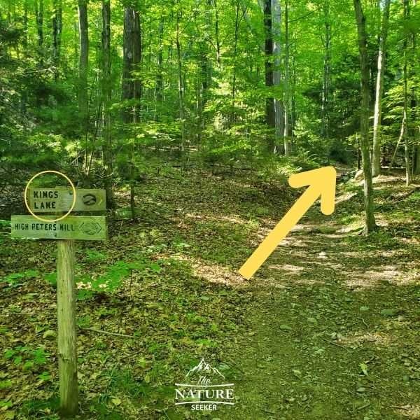
- Kings Lane (represents a part of the loop which is the yellow trail).
The 7 reasons to explore Lost City Loop:
- It has amazing scenic views.
- The hike itself is an awesome experience.
- Caving and bouldering experiences available.
- There is a beautiful swimming hole nearby (Split Rock, a popular Catskill swimming hole).
- There are other beautiful trails to the surrounding areas (Lake Minnewaska and Mohonk Preserve).
- There are historic sites nearby (old cemetery, mine, ect…)
- Picnic spots available nearby (great for more than just hiking, but relaxing).
What to expect from hiking the Lost City Loop:
It’s actually a simple hike in that it’s just a loop but there are parts where you may think you’re lost so just to be sure, read up on how to navigate it properly so that doesn’t happen:
1) First you will want to park at the Split Rock Coxing Hill Parking lot:
Remember, it’s $15 per person and also the parking lot is pretty limited in space (maybe for 20-25 cars). The best time to go here would be very early OR a few hours before sunset (most people leave by then).
2) Once you park, you will see the trailhead with a light blue marker (start of the trail):
The trail to the Lost City Loop begins off the parking lot. Once you enter, you will immediately find a very old cemetery. You will continue along this light blue trail for about 1/4 a mile. The markers are pretty easy to spot, but if you’re worried about getting lost in the woods, read up on that article as it’ll help.
3) You will then cross a yellow/light blue fork in the road (Kings Lane):
The blue marker goes left, while the yellow marker (known as Kings Lane) turns right. It honestly doesn’t matter whether you take a left or right since it is a loop but most people recommend taking a right and going to the yellow trail, then coming back around to the same fork.
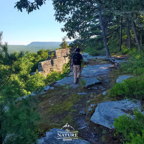
The yellow trail will go on for about 1.5 miles. It’ll be an uphill walk at first, but it will lead to the giant cliffs shortly after you make the turn at the fork. This will take you to the overlook section of the Kings Loop Escarpment area which is the most scenic part of the hike. As you continue along this path, you will pass great views of the Catskills, and even a cave area. There’s a lot to see and hike through here so take your time and enjoy this!
4) Continue following the yellow trail for 1.5 miles until you see another fork for the light blue/yellow trail:
One thing I want to mention is that as you are walking at the top of this hike on the yellow trail, the trail markers will not appear as often and sometimes you’ll wonder if you’re lost. The truth is that as long as you continue walking along the ridge, along the obvious path, you should be OK, but if you do feel like you’re lost, just go back to the previous trail marker. But moving forward, the yellow trail will meet up with another fork:
This time around, the fork will be at the top of the cliffs and you will take a left and get back on the light blue trail. This will take you back to the same original fork you came across where you took the yellow trail. From there, you’ll just continue following the same light blue trail back to the parking lot. In total, the trip is going to be about 2.5 miles. Afterwards if there’s time you can explore the swimming hole nearby and see other stuff.
Other awesome nearby hikes to explore:

I’m going to share some specific trails within an hours drive of this one you can also check out if you have the time (or interest). Here’s a few:
Obviously there are many more parks and trails all around Lost City Loop to explore, but I’m keeping it within an hours drive from there. I would recommend exploring the Mohonk and Lake Minneswaska area when you finish this hike (or perhaps doing this hike after exploring those places). The Lost City Loop is an awesome hike that I sincerely enjoyed doing twice so far and will continue to revisit as there is so much more to check out along and outside the trail, but if you enjoy this post and tried the hike, I’d love to hear what you thought of it!
Hiking gear needed for the Lost City Loop? Maybe:
That depends on what you intend to do. Most of the hike is pretty much on easy land to walk on so you can actually do this in regular footwear (which is something I don’t normally say for these hikes). But I would invest in good hiking gear because this isn’t the only hike there and if you do others, you’ll find mixed levels out there that may or may not require it.