How to Hike The Ledges Trail in Cuyahoga Valley
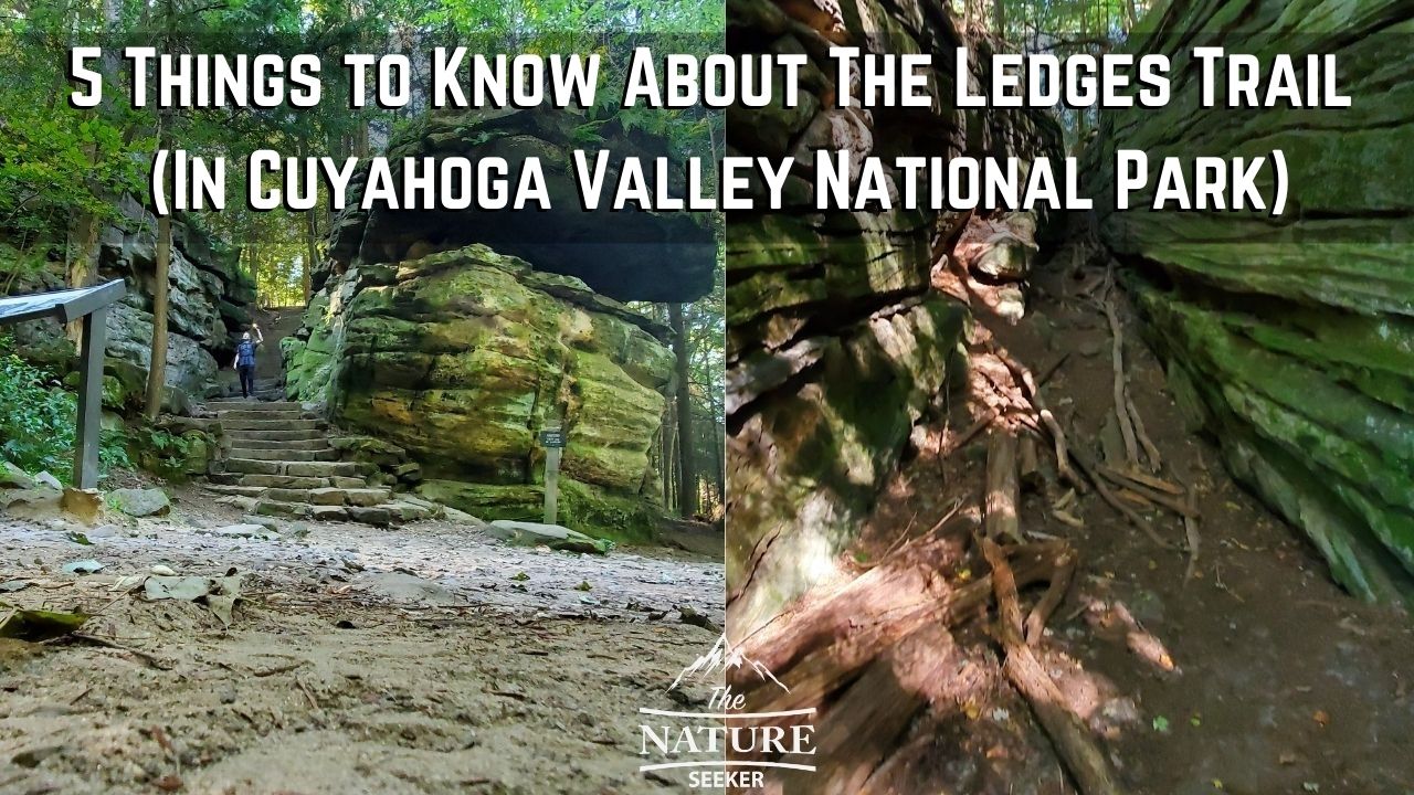
In my personal opinion, the Ledges Trail at Cuyahoga Valley National Park isn’t just the most beautiful place to explore in that park, but it’s also one of the most beautiful hikes I’ve ever done anywhere.
However, prior to hiking the Ledges Trail, I ran in a lot of issues, from basic info on the trail, as well as things like even knowing it existed, to finding it, and then finding the best place to start hiking it. All of this is something you may encounter before coming here, so this post is going to help clear this up by sharing 5 things you need to know beforehand.
It’ll help you save time because in my case, when I went here, I wasted over an hour figuring it all out and this is mainly due to the fact that I had no rangers telling me where to go, and no good online info to tell me exactly what I needed to know about hiking the Ledges Trail. However, by reading this post, you won’t have this problem!
Some quick info about the Ledges Trail (before you go):
 How long is Ledges trail?
 How long is Ledges trail?
The Ledges trail is only about 3 miles long.
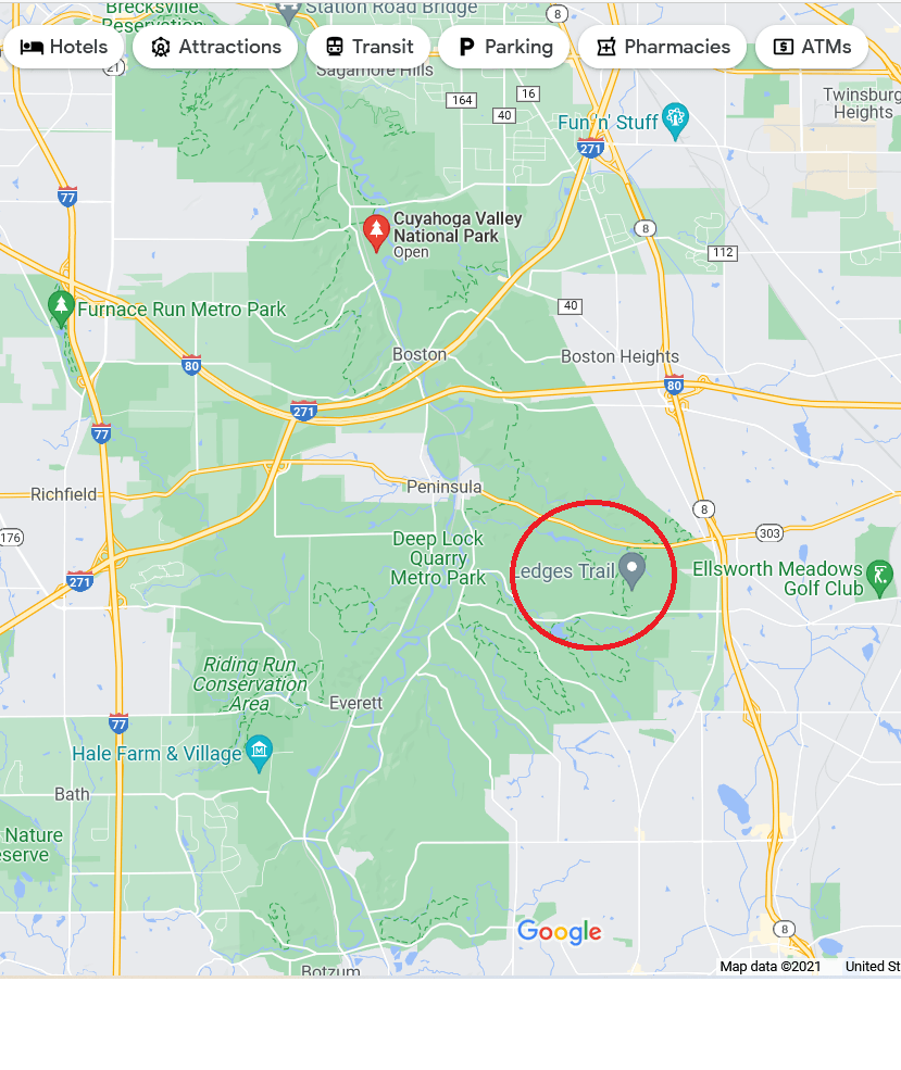
Where is Ledges trail?
There are several trails under this name, but the most popular Ledges trail is in Cuyahoga Valley National Park.
Further info on other Ledges trails:
You’ll find then all across the United States, including one in Ohio, Connecticut and even New York.
Now I say this not just because of the fact, but also because if you do input this trail into your GPS, make sure it’s the right one (the one in Cuyahoga Valley National Park). While the other Ledges Trails are also nice, you’re want to a plan a trip to the right one!
Here are 5 things to know before hiking The Ledges Trail:
- There’s 3 different access points to The Ledges Trail.
- The Ledges trail is about 2 miles long.
- It’s very easy to walk and hike The Ledges Trail.
- Here is a map of the most beautiful areas of the Ledges Trail.
- You can go over the top of the trail to avoid going all the way around it.
Most of these things may seem like obvious stuff, but when I went here, I didn’t have access to this info and had to figure it all out on the spot. Let me go over each of these things so you know what to expect before going here:
1) There’s 3 access points (parking areas) to the Ledges Trail:
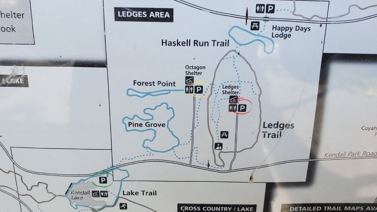
- Ledges Trailhead parking lot (red). This is the closest to the trail (eastern side).
- Octagon Shelter (yellow). Also very close to the trail (western end).
- Kendall Lake Parking lot (green). It’s about 1 mile away at Kendall Lake (south west side of trail).
When I personally went here, I began at Kendall Lake because I had no clue that the other places existed. My GPS just took me to what I considered to be the closest access point to this trail. Funny enough later on, my GPS decided to show me the other spots on this map. Only after hiking it did I realize there were 2 more parking areas which would have saved me several miles of hiking, so if you’re looking to get to and start the Ledges Trail quickly, start in either the red area or yellow area. If you start at Kendall Lake, you’ll have to hike a bit more to get to it (which is also fine if you’re into that).
2) The Ledges Trail is only about 2 miles long (loop trail):
There isn’t much else to say here other than you have 2 choices when doing this trail: You can either do it clockwise or counter clock wise. Either option is fine, as long as you end up in the same parking area you started at. I would recommend starting this trail in the morning hours to get the best views because as it gets into the later hours of the afternoon, it does get darker there and it might be tough to see all the nice sights.
3) The Ledges trail is very easy to hike through:
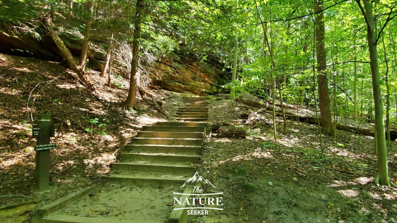
There’s nothing difficult in my opinion about hiking through this trail, which makes it better to enjoy the views for most people. I personally saw people of all types hiking here: Families, trail runners, couples, ect…
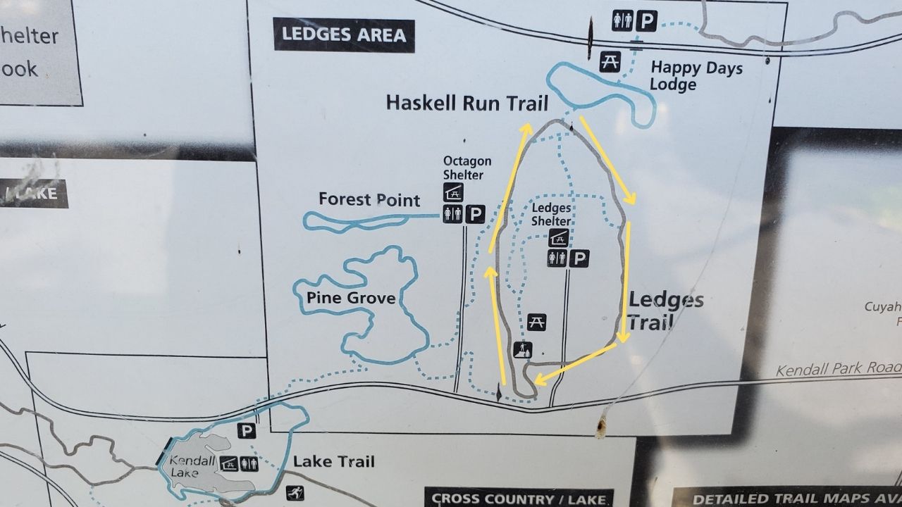
4) Here’s a map of the best spots to see on The Ledges Trail:
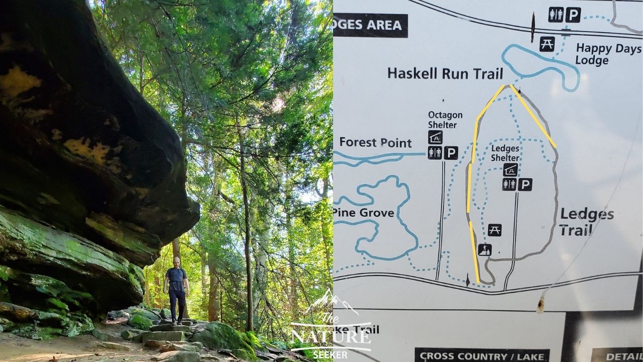
The spots I labeled as yellow on that map are where I think you’ll find the best places. They’re all boulder areas, and while the Ledges trail actually offers more things to see such as:
- A giant field near the parking lot by the trailhead where you start.
- And a scenic overlook that people like to congregate at.
In my opinion, those 2 places are a bit overrated and the main thing to really enjoy is the boulder hike through the Ledges Trail.
5) You can go over the top of the Ledges Trail (little shortcuts are available):
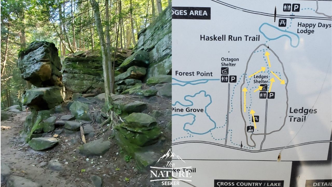
Going all the way around The Ledges Trail is actually optional and there’s little paths/shortcuts available that’ll take you over the trail which you can use to cut through to other sides of it. I’ve included a map with those spots above, and I did see a lot of people using them.
You won’t really find many nice views up there in my opinion, but if you’re tight on time and don’t want to do the full loop trail, then I’d take one or more of these shortcuts (make sure to take a picture of the trail map, as some of these shortcuts might lead you to other places where you don’t want to go). In my opinion, the best place to be on this trail is on the loop trail itself and hiking past the boulders. Those offer the best sights, but you can keep these shortcuts in mind.
Some final thoughts about the Ledges Trail:
It really is stunning and that’s really it in terms of views. Other than that, I strongly recommend exploring the greater Cuyahoga Valley National Park area as this is one of the many great hikes and sights there.
Related:
All of the above mentioned parks have great hikes and trails, some of which have similar sights that you see on the Ledges Trail.