Toadstool Hoodoos Trail: What to Know Before Hiking Here
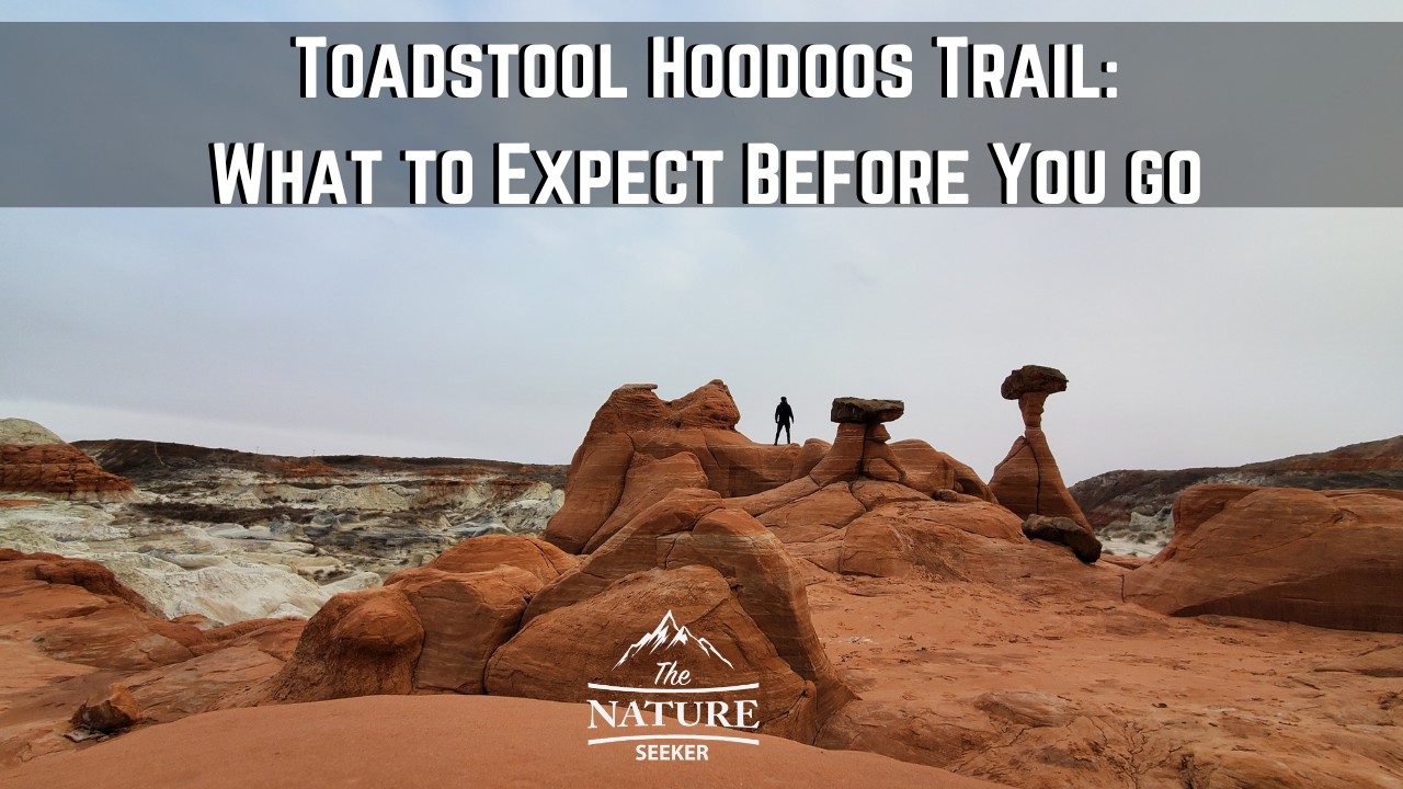
The Toadstool Hoodoos trail in Utah is a very underrated hike in my opinion and also one of the easiest places to see if you’re visiting Kanab or Page AZ. In this post, I’m going to share with you my experiences exploring it and what to expect if you visit it too.
Quick info:
- Name: Toadstool Hoodoos trail.
- Location: It’s in Utah. The trailhead is by road 89.
- Hiking distance: 3 miles in and out.
- Difficulty: Easy.
5 things to know:
- The trail is short (About 1-2 miles to the Toadstool Hoodoos).
- Despite being short, if you do this hike in the spring/summer, bring a lot of water.
- If it’s hot, only do this hike early in the morning (or ideally during winter).
- The entire hike is exposed to the sun (very few shaded areas), so wear a hat.
- The entire hike is basically northward to reach the Toadstool Hoodoos. Once you’re done, you’ll just head south on the same trail to the trailhead.
Starting out:
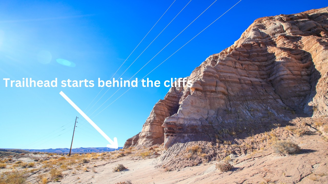
There’s not many good Toadstool Hoodoos Trailhead photos to show you where to start this hike, but the best way to find it is via Google Maps. Here’s the Toadstool Hoodoos trailhead. It’s literally off road 89 and you may see several cars parked in the area. There isn’t any big sign to do this hike so it might be easy to miss unless you have Google maps showing you the spot.
The parking lot isn’t very big but you will see a fence by the trailhead sign. Just park your car, walk past the fence and you will start on the hike. The idea is to keep left as you’re walking (you will see telephone poles to your right, but don’t go to them). Stay closer to the cliffs area when the hike starts.
Entering the wash area:
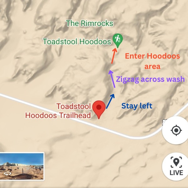
The first section of the hike (from the parking lot to the wash) is about 1/2 a mile. From there you’ll enter the “wash area” and I like to think of it is part 2 of the hike and this part of the trail might be the most “difficult” are of the hike (in reality it isn’t). You will be walking in a zigzag manner through a river wash area and will see signs saying which direction to go to continue on the Toadstool Hoodoos trail. The trail is pretty easy to navigate but for any sort of trail (even this one), I’d recommend Alltrails. You probably won’t even need this app here but I’d have it ready just in case.
There are several walk able paths here but you’re going to want to stay at the top of the wash area (just in case there’s water flowing which is rare). You may also see a lot of other people on the trail too (depending on when you visit). Typically during winter you will see maybe 2-5 people on the whole trail. Spring and summer time, this hike usually has a lot of people on it all day.
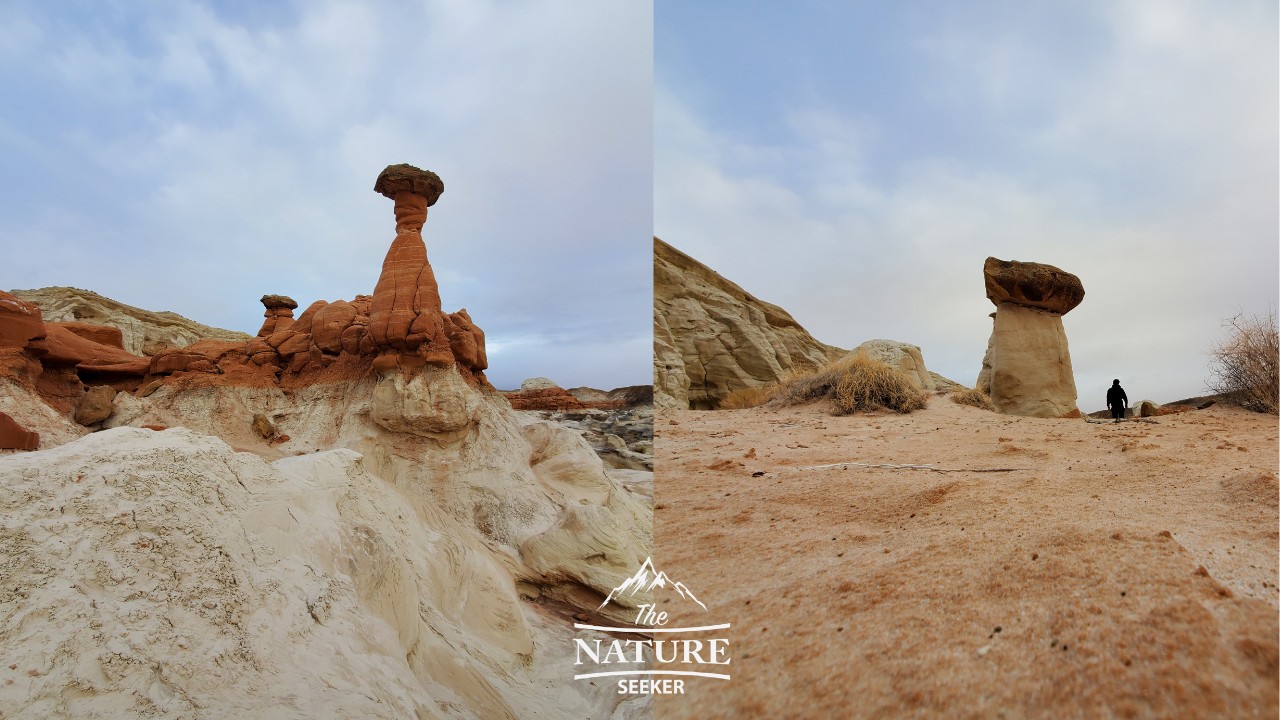
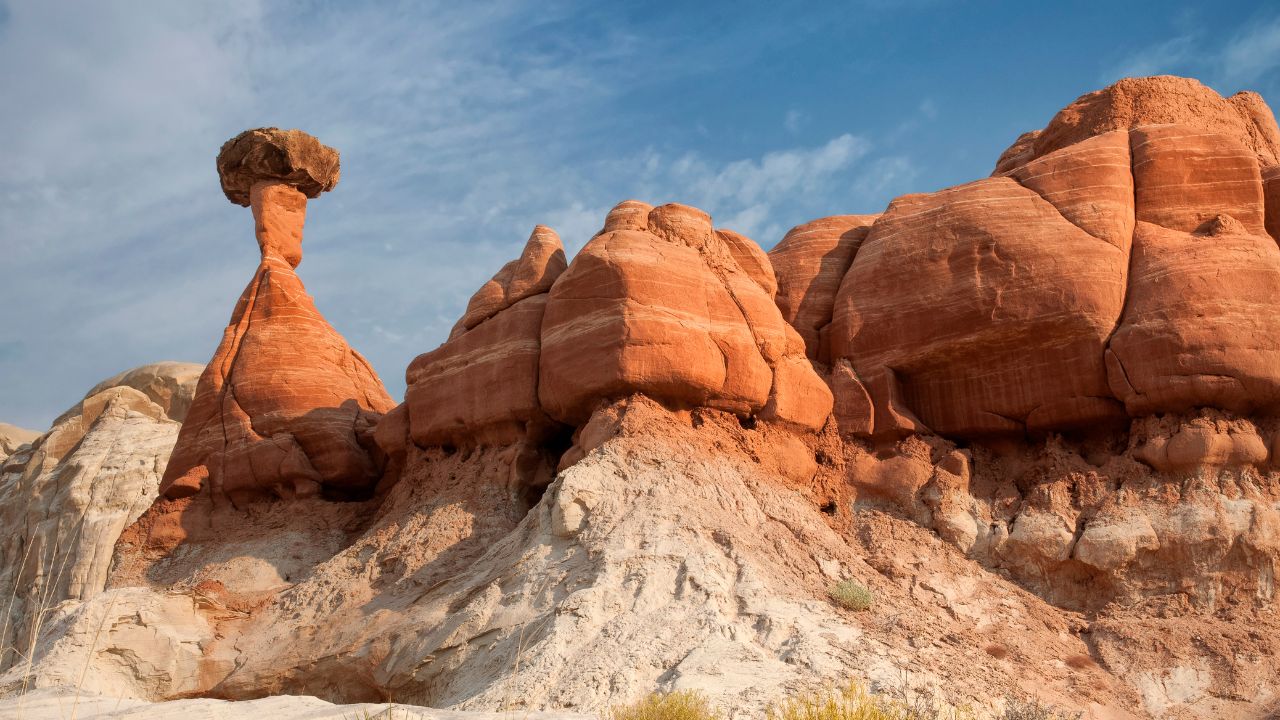
Entering the Toadstool Hoodoos area:
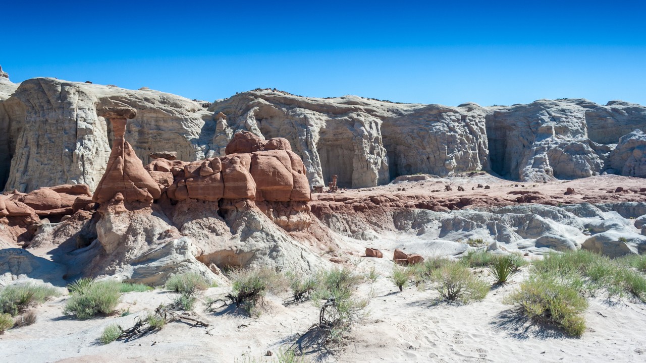
You’ll walk up and out of the wash and see the Toadstool Hoodoos in the distance, but at the same time you will also be an a much more open area of the hike where you will see amazing sand/rock and canyon formations so I wouldn’t just focus on the Toadstools here. But in any case, you will be walking towards them (the Toadstool Hoodoos), make your way up and enter a white sandy or white muddy area (depending on the season).
There will be several amazing looking Toadstool Hoodoos to explore here including ones that are pink rock and white rock too. Nearby (if you continue north), you will see a white canyon wall with some balanced rocks on it. As far as I know there is no way to go up there and this is where the trail officially stops.
I would recommend taking your time in this section of the hike (as long as it isn’t very hot) because it is very scenic and there is a lot of open space between the Toadstool Hoodoos to walk around and enjoy the area. When I was exploring this trail, I only saw 2 other people before being there all by myself and that was an incredible experience. Just so you know, for cell phone reception, you will likely have none of it the further you go into this trail.
Finishing up the hike:
It’s simple, you will just walk back down to the wash area, continue through there and back to the parking lot. This time around, you will want to stay to your right to make sure you are on the path.
In short: Just hike south as you will reach the trailhead this way. From here, you will have 3 options:
- Head to Page Arizona (if you’re planning on staying there or just heading in that direction).
- Head to Kanab Utah (same idea if you’re planning on going/staying there).
- Explore more hikes near Toadstool Hoodoos.
Related:
My thoughts after hiking Toadstool Hoodoos:
Again, I was very surprised at how awesome this trail was. I originally sought out to explore White Pocket and other hikes I thought were awesome, but “thanks” to bad weather and timing, because I cancelled that, I not only got a chance to explore and enjoy Toadstool Hoodoos, but that experience opened up even more amazing hikes and scenic drives that were nearby it. Now thanks to those circumstances, I have an even bigger itinerary of things to explore next time I am revisiting this area!
Thanks for checking out my post on Toadstool Hoodoos, I hope it helps you enjoy not only the trail but the other recommendations nearby and if you have any questions about any of them, let me know!